You are here: Home > Network List > TA - USArray Transportable Network (new EarthScope stations) Stations List
> Station K58A Earlville, NY, USA > Earthquake Result Viewer
K58A Earlville, NY, USA - Earthquake Result Viewer
| Earthquake location: |
Near Coast Of Nicaragua |
| Earthquake latitude/longitude: |
12.6/-87.7 |
| Earthquake time(UTC): |
2014/03/02 (061) 09:37:54 GMT |
| Earthquake Depth: |
60 km |
| Earthquake Magnitude: |
6.2 MWW, 6.2 MWB, 6.2 MWC, 6.3 MWC |
| Earthquake Catalog/Contributor: |
NEIC PDE/NEIC COMCAT |
|
| Network: |
TA USArray Transportable Network (new EarthScope stations) |
| Station: |
K58A Earlville, NY, USA |
| Lat/Lon: |
42.76 N/75.65 W |
| Elevation: |
509 m |
|
| Distance: |
31.9 deg |
| Az: |
16.919 deg |
| Baz: |
202.696 deg |
| Ray Param: |
0.07876372 |
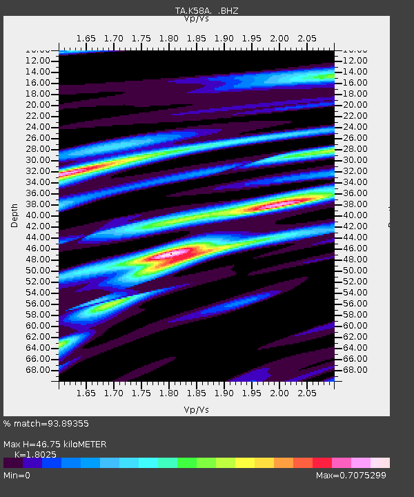
| Estimated Moho Depth: |
46.75 km |
| Estimated Crust Vp/Vs: |
1.80 |
| Assumed Crust Vp: |
6.419 km/s |
| Estimated Crust Vs: |
3.561 km/s |
| Estimated Crust Poisson's Ratio: |
0.28 |
|
| Radial Match: |
93.89355 % |
| Radial Bump: |
317 |
| Transverse Match: |
79.10264 % |
| Transverse Bump: |
382 |
| SOD ConfigId: |
626651 |
| Insert Time: |
2014-04-20 23:30:35.459 +0000 |
| GWidth: |
2.5 |
| Max Bumps: |
400 |
| Tol: |
0.001 |
|
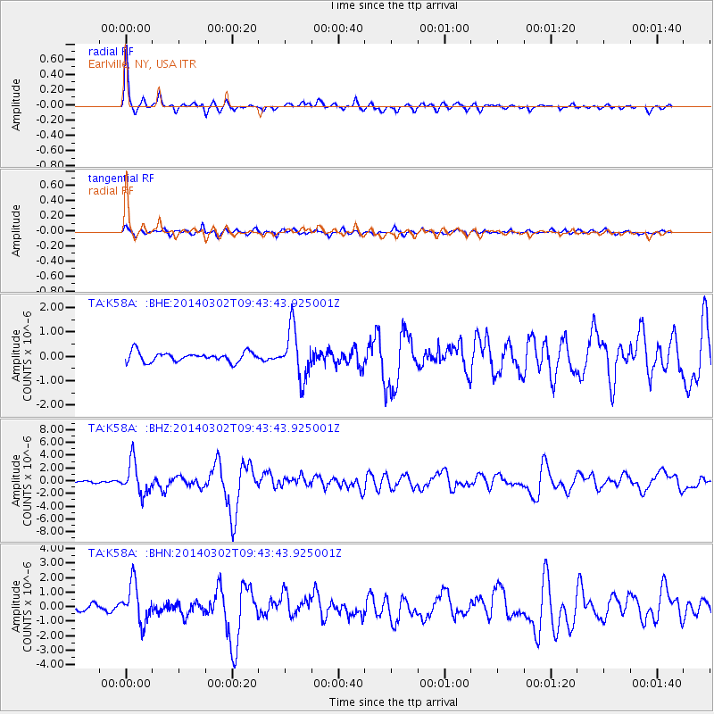
Signal To Noise
| Channel | StoN | STA | LTA |
| TA:K58A: :BHZ:20140302T09:43:43.925001Z | 9.979108 | 2.4925703E-6 | 2.4977888E-7 |
| TA:K58A: :BHN:20140302T09:43:43.925001Z | 8.2739525 | 1.3363231E-6 | 1.6150965E-7 |
| TA:K58A: :BHE:20140302T09:43:43.925001Z | 5.1595354 | 1.0220732E-6 | 1.9809403E-7 |
| Arrivals |
| Ps | 6.3 SECOND |
| PpPs | 19 SECOND |
| PsPs/PpSs | 25 SECOND |


