You are here: Home > Network List > TA - USArray Transportable Network (new EarthScope stations) Stations List
> Station K62A Royalston, MA, USA > Earthquake Result Viewer
K62A Royalston, MA, USA - Earthquake Result Viewer
| Earthquake location: |
Near Coast Of Nicaragua |
| Earthquake latitude/longitude: |
12.6/-87.7 |
| Earthquake time(UTC): |
2014/03/02 (061) 09:37:54 GMT |
| Earthquake Depth: |
60 km |
| Earthquake Magnitude: |
6.2 MWW, 6.2 MWB, 6.2 MWC, 6.3 MWC |
| Earthquake Catalog/Contributor: |
NEIC PDE/NEIC COMCAT |
|
| Network: |
TA USArray Transportable Network (new EarthScope stations) |
| Station: |
K62A Royalston, MA, USA |
| Lat/Lon: |
42.67 N/72.23 W |
| Elevation: |
289 m |
|
| Distance: |
32.9 deg |
| Az: |
21.234 deg |
| Baz: |
208.649 deg |
| Ray Param: |
0.07832919 |
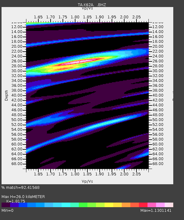
| Estimated Moho Depth: |
26.0 km |
| Estimated Crust Vp/Vs: |
1.82 |
| Assumed Crust Vp: |
6.419 km/s |
| Estimated Crust Vs: |
3.532 km/s |
| Estimated Crust Poisson's Ratio: |
0.28 |
|
| Radial Match: |
92.41568 % |
| Radial Bump: |
227 |
| Transverse Match: |
64.97349 % |
| Transverse Bump: |
400 |
| SOD ConfigId: |
626651 |
| Insert Time: |
2014-04-20 23:30:47.361 +0000 |
| GWidth: |
2.5 |
| Max Bumps: |
400 |
| Tol: |
0.001 |
|

Signal To Noise
| Channel | StoN | STA | LTA |
| TA:K62A: :BHZ:20140302T09:43:52.675001Z | 10.72207 | 2.4965314E-6 | 2.3284043E-7 |
| TA:K62A: :BHN:20140302T09:43:52.675001Z | 7.3533435 | 1.6300352E-6 | 2.2167265E-7 |
| TA:K62A: :BHE:20140302T09:43:52.675001Z | 2.979824 | 8.954275E-7 | 3.0049677E-7 |
| Arrivals |
| Ps | 3.6 SECOND |
| PpPs | 11 SECOND |
| PsPs/PpSs | 14 SECOND |


