You are here: Home > Network List > TA - USArray Transportable Network (new EarthScope stations) Stations List
> Station K63A Dunstable, MA, USA > Earthquake Result Viewer
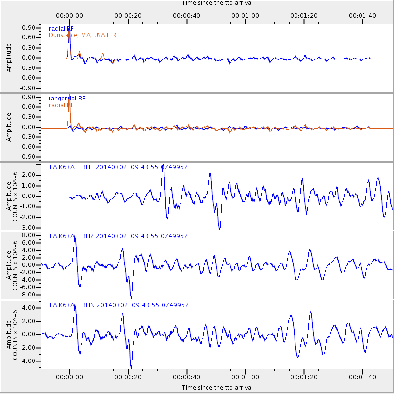
K63A Dunstable, MA, USA - Earthquake Result Viewer

| Earthquake location: |
Near Coast Of Nicaragua |
| Earthquake latitude/longitude: |
12.6/-87.7 |
| Earthquake time(UTC): |
2014/03/02 (061) 09:37:54 GMT |
| Earthquake Depth: |
60 km |
| Earthquake Magnitude: |
6.2 MWW, 6.2 MWB, 6.2 MWC, 6.3 MWC |
| Earthquake Catalog/Contributor: |
NEIC PDE/NEIC COMCAT |
|
| Network: |
TA USArray Transportable Network (new EarthScope stations) |
| Station: |
K63A Dunstable, MA, USA |
| Lat/Lon: |
42.69 N/71.53 W |
| Elevation: |
68 m |
|
| Distance: |
33.1 deg |
| Az: |
22.047 deg |
| Baz: |
209.808 deg |
| Ray Param: |
0.07820293 |
| Estimated Moho Depth: |
31.5 km |
| Estimated Crust Vp/Vs: |
1.60 |
| Assumed Crust Vp: |
6.419 km/s |
| Estimated Crust Vs: |
4.006 km/s |
| Estimated Crust Poisson's Ratio: |
0.18 |
|
| Radial Match: |
94.594826 % |
| Radial Bump: |
245 |
| Transverse Match: |
64.27015 % |
| Transverse Bump: |
400 |
| SOD ConfigId: |
626651 |
| Insert Time: |
2014-04-20 23:30:49.341 +0000 |
| GWidth: |
2.5 |
| Max Bumps: |
400 |
| Tol: |
0.001 |
|
Signal To Noise
| Channel | StoN | STA | LTA |
| TA:K63A: :BHZ:20140302T09:43:55.074995Z | 8.304686 | 3.6520498E-6 | 4.3975777E-7 |
| TA:K63A: :BHN:20140302T09:43:55.074995Z | 7.0829344 | 1.9523152E-6 | 2.756365E-7 |
| TA:K63A: :BHE:20140302T09:43:55.074995Z | 5.4673615 | 1.4134232E-6 | 2.5852017E-7 |
| Arrivals |
| Ps | 3.2 SECOND |
| PpPs | 12 SECOND |
| PsPs/PpSs | 15 SECOND |


