You are here: Home > Network List > TA - USArray Transportable Network (new EarthScope stations) Stations List
> Station L60A Shokan, NY, USA > Earthquake Result Viewer
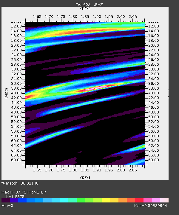
L60A Shokan, NY, USA - Earthquake Result Viewer
| Earthquake location: |
Near Coast Of Nicaragua |
| Earthquake latitude/longitude: |
12.6/-87.7 |
| Earthquake time(UTC): |
2014/03/02 (061) 09:37:54 GMT |
| Earthquake Depth: |
60 km |
| Earthquake Magnitude: |
6.2 MWW, 6.2 MWB, 6.2 MWC, 6.3 MWC |
| Earthquake Catalog/Contributor: |
NEIC PDE/NEIC COMCAT |
|
| Network: |
TA USArray Transportable Network (new EarthScope stations) |
| Station: |
L60A Shokan, NY, USA |
| Lat/Lon: |
41.99 N/74.22 W |
| Elevation: |
388 m |
|
| Distance: |
31.6 deg |
| Az: |
19.354 deg |
| Baz: |
205.724 deg |
| Ray Param: |
0.078879446 |
| Estimated Moho Depth: |
37.75 km |
| Estimated Crust Vp/Vs: |
1.89 |
| Assumed Crust Vp: |
6.283 km/s |
| Estimated Crust Vs: |
3.329 km/s |
| Estimated Crust Poisson's Ratio: |
0.30 |
|
| Radial Match: |
86.02148 % |
| Radial Bump: |
256 |
| Transverse Match: |
73.01184 % |
| Transverse Bump: |
400 |
| SOD ConfigId: |
626651 |
| Insert Time: |
2014-04-20 23:31:15.737 +0000 |
| GWidth: |
2.5 |
| Max Bumps: |
400 |
| Tol: |
0.001 |
|

Signal To Noise
| Channel | StoN | STA | LTA |
| TA:L60A: :BHZ:20140302T09:43:41.550001Z | 10.420248 | 3.3771055E-6 | 3.240907E-7 |
| TA:L60A: :BHN:20140302T09:43:41.550001Z | 3.8150156 | 1.7442453E-6 | 4.5720526E-7 |
| TA:L60A: :BHE:20140302T09:43:41.550001Z | 4.423712 | 1.1436364E-6 | 2.5852415E-7 |
| Arrivals |
| Ps | 5.7 SECOND |
| PpPs | 16 SECOND |
| PsPs/PpSs | 22 SECOND |


