You are here: Home > Network List > CI - Caltech Regional Seismic Network Stations List
> Station MPM Manuel Prospect Mine, California, USA > Earthquake Result Viewer
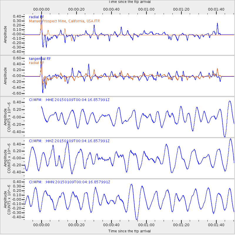
MPM Manuel Prospect Mine, California, USA - Earthquake Result Viewer
*The percent match for this event was below the threshold and hence no stack was calculated.
| Earthquake location: |
Pacific-Antarctic Ridge |
| Earthquake latitude/longitude: |
-54.3/-132.9 |
| Earthquake time(UTC): |
2015/01/08 (008) 23:51:44 GMT |
| Earthquake Depth: |
10 km |
| Earthquake Magnitude: |
5.4 MW, 5.1 mb, 5.3 MS |
| Earthquake Catalog/Contributor: |
ISC/ISC |
|
| Network: |
CI Caltech Regional Seismic Network |
| Station: |
MPM Manuel Prospect Mine, California, USA |
| Lat/Lon: |
36.06 N/117.49 W |
| Elevation: |
185 m |
|
| Distance: |
90.9 deg |
| Az: |
12.456 deg |
| Baz: |
188.983 deg |
| Ray Param: |
$rayparam |
*The percent match for this event was below the threshold and hence was not used in the summary stack. |
|
| Radial Match: |
58.166256 % |
| Radial Bump: |
400 |
| Transverse Match: |
71.917534 % |
| Transverse Bump: |
400 |
| SOD ConfigId: |
3390531 |
| Insert Time: |
2019-04-15 23:43:15.376 +0000 |
| GWidth: |
2.5 |
| Max Bumps: |
400 |
| Tol: |
0.001 |
|
Signal To Noise
| Channel | StoN | STA | LTA |
| CI:MPM: :HHZ:20150109T00:04:16.857991Z | 0.5572792 | 1.4280444E-7 | 2.5625292E-7 |
| CI:MPM: :HHN:20150109T00:04:16.857991Z | 1.6801615 | 1.7795949E-7 | 1.0591808E-7 |
| CI:MPM: :HHE:20150109T00:04:16.857991Z | 0.7019777 | 9.202945E-8 | 1.3110025E-7 |
| Arrivals |
| Ps | |
| PpPs | |
| PsPs/PpSs | |


