You are here: Home > Network List > UU - University of Utah Regional Network Stations List
> Station TMU Trail Mountain (BB), UT, USA > Earthquake Result Viewer
TMU Trail Mountain (BB), UT, USA - Earthquake Result Viewer
| Earthquake location: |
Near Coast Of Nicaragua |
| Earthquake latitude/longitude: |
12.6/-87.7 |
| Earthquake time(UTC): |
2014/03/02 (061) 09:37:54 GMT |
| Earthquake Depth: |
60 km |
| Earthquake Magnitude: |
6.2 MWW, 6.2 MWB, 6.2 MWC, 6.3 MWC |
| Earthquake Catalog/Contributor: |
NEIC PDE/NEIC COMCAT |
|
| Network: |
UU University of Utah Regional Network |
| Station: |
TMU Trail Mountain (BB), UT, USA |
| Lat/Lon: |
39.30 N/111.21 W |
| Elevation: |
2731 m |
|
| Distance: |
33.8 deg |
| Az: |
326.179 deg |
| Baz: |
135.543 deg |
| Ray Param: |
0.0778954 |
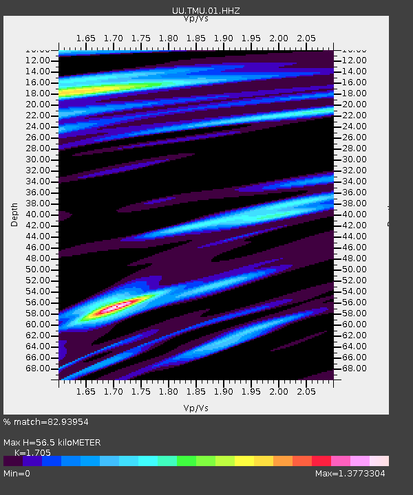
| Estimated Moho Depth: |
56.5 km |
| Estimated Crust Vp/Vs: |
1.71 |
| Assumed Crust Vp: |
6.207 km/s |
| Estimated Crust Vs: |
3.64 km/s |
| Estimated Crust Poisson's Ratio: |
0.24 |
|
| Radial Match: |
82.93954 % |
| Radial Bump: |
400 |
| Transverse Match: |
66.54031 % |
| Transverse Bump: |
376 |
| SOD ConfigId: |
626651 |
| Insert Time: |
2014-04-20 23:35:04.147 +0000 |
| GWidth: |
2.5 |
| Max Bumps: |
400 |
| Tol: |
0.001 |
|

Signal To Noise
| Channel | StoN | STA | LTA |
| UU:TMU:01:HHZ:20140302T09:44:00.869001Z | 4.9436007 | 3.3422744E-8 | 6.7608097E-9 |
| UU:TMU:01:HHN:20140302T09:44:00.869001Z | 2.6675205 | 1.9549622E-8 | 7.328762E-9 |
| UU:TMU:01:HHE:20140302T09:44:00.869001Z | 2.4235044 | 1.5126068E-8 | 6.241403E-9 |
| Arrivals |
| Ps | 6.9 SECOND |
| PpPs | 23 SECOND |
| PsPs/PpSs | 30 SECOND |


