You are here: Home > Network List > WU - The Southern Ontario Seismic Network Stations List
> Station DELO Deloro Mine, Ontario, Canada > Earthquake Result Viewer
DELO Deloro Mine, Ontario, Canada - Earthquake Result Viewer
| Earthquake location: |
Near Coast Of Nicaragua |
| Earthquake latitude/longitude: |
12.6/-87.7 |
| Earthquake time(UTC): |
2014/03/02 (061) 09:37:54 GMT |
| Earthquake Depth: |
60 km |
| Earthquake Magnitude: |
6.2 MWW, 6.2 MWB, 6.2 MWC, 6.3 MWC |
| Earthquake Catalog/Contributor: |
NEIC PDE/NEIC COMCAT |
|
| Network: |
WU The Southern Ontario Seismic Network |
| Station: |
DELO Deloro Mine, Ontario, Canada |
| Lat/Lon: |
44.52 N/77.62 W |
| Elevation: |
213 m |
|
| Distance: |
33.0 deg |
| Az: |
13.274 deg |
| Baz: |
198.264 deg |
| Ray Param: |
0.078264594 |
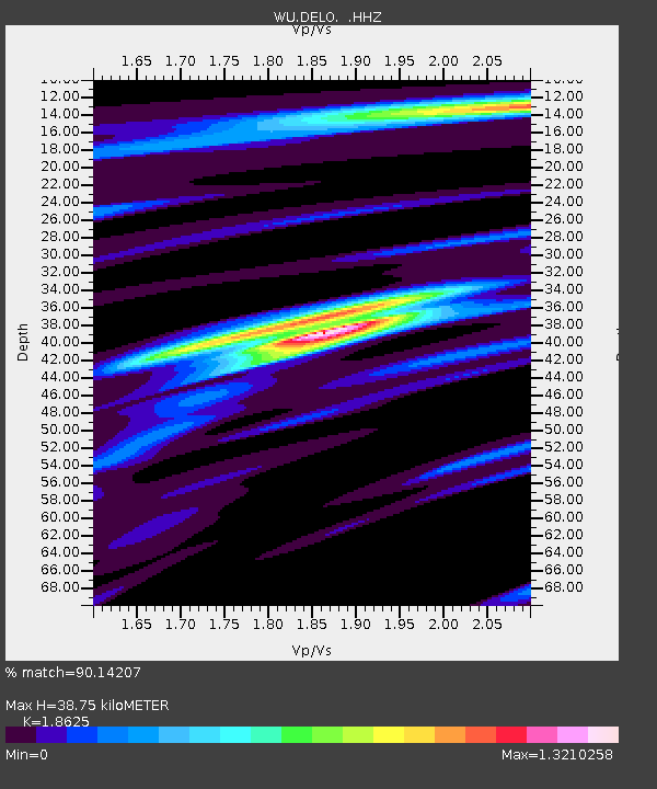
| Estimated Moho Depth: |
38.75 km |
| Estimated Crust Vp/Vs: |
1.86 |
| Assumed Crust Vp: |
6.577 km/s |
| Estimated Crust Vs: |
3.531 km/s |
| Estimated Crust Poisson's Ratio: |
0.30 |
|
| Radial Match: |
90.14207 % |
| Radial Bump: |
238 |
| Transverse Match: |
55.924805 % |
| Transverse Bump: |
333 |
| SOD ConfigId: |
626651 |
| Insert Time: |
2014-04-20 23:36:47.004 +0000 |
| GWidth: |
2.5 |
| Max Bumps: |
400 |
| Tol: |
0.001 |
|

Signal To Noise
| Channel | StoN | STA | LTA |
| WU:DELO: :HHZ:20140302T09:43:53.900007Z | 11.494531 | 2.0485757E-6 | 1.7822177E-7 |
| WU:DELO: :HHN:20140302T09:43:53.900007Z | 5.3780313 | 1.2861861E-6 | 2.3915558E-7 |
| WU:DELO: :HHE:20140302T09:43:53.900007Z | 2.5981395 | 4.474771E-7 | 1.7222982E-7 |
| Arrivals |
| Ps | 5.5 SECOND |
| PpPs | 16 SECOND |
| PsPs/PpSs | 21 SECOND |


