You are here: Home > Network List > AF - Africa Array Stations List
> Station DODT Dodoma, Tanzania > Earthquake Result Viewer
DODT Dodoma, Tanzania - Earthquake Result Viewer
| Earthquake location: |
Ryukyu Islands, Japan |
| Earthquake latitude/longitude: |
27.4/127.4 |
| Earthquake time(UTC): |
2014/03/02 (061) 20:11:23 GMT |
| Earthquake Depth: |
119 km |
| Earthquake Magnitude: |
6.5 MWW, 6.4 MWB, 6.5 MWC, 6.6 MI, 6.7 MI |
| Earthquake Catalog/Contributor: |
NEIC PDE/NEIC COMCAT |
|
| Network: |
AF Africa Array |
| Station: |
DODT Dodoma, Tanzania |
| Lat/Lon: |
6.19 S/35.75 E |
| Elevation: |
1114 m |
|
| Distance: |
94.2 deg |
| Az: |
265.268 deg |
| Baz: |
62.988 deg |
| Ray Param: |
0.041011184 |
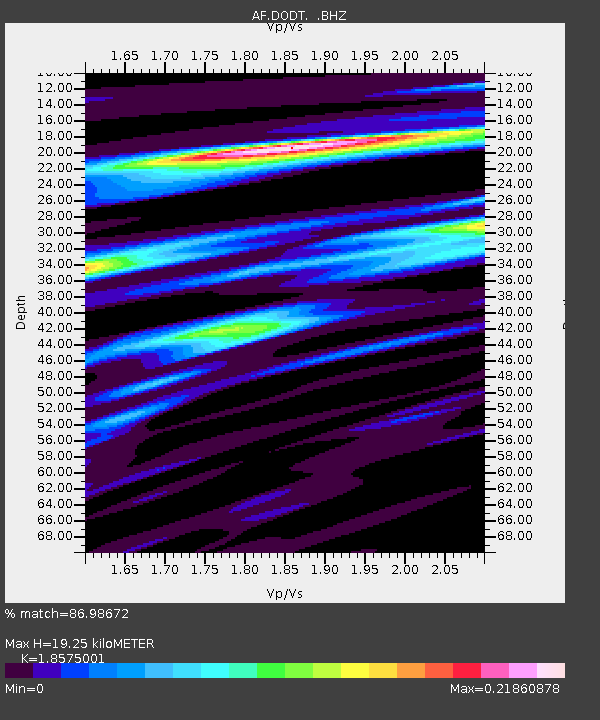
| Estimated Moho Depth: |
19.25 km |
| Estimated Crust Vp/Vs: |
1.86 |
| Assumed Crust Vp: |
6.65 km/s |
| Estimated Crust Vs: |
3.58 km/s |
| Estimated Crust Poisson's Ratio: |
0.30 |
|
| Radial Match: |
86.98672 % |
| Radial Bump: |
376 |
| Transverse Match: |
72.493675 % |
| Transverse Bump: |
400 |
| SOD ConfigId: |
626651 |
| Insert Time: |
2014-04-20 23:55:13.200 +0000 |
| GWidth: |
2.5 |
| Max Bumps: |
400 |
| Tol: |
0.001 |
|

Signal To Noise
| Channel | StoN | STA | LTA |
| AF:DODT: :BHZ:20140302T20:23:57.78498Z | 27.901327 | 9.865797E-13 | 3.53596E-14 |
| AF:DODT: :BHN:20140302T20:23:57.78498Z | 2.5652754 | 7.4271135E-14 | 2.8952498E-14 |
| AF:DODT: :BHE:20140302T20:23:57.78498Z | 5.4651375 | 8.554652E-14 | 1.5653133E-14 |
| Arrivals |
| Ps | 2.5 SECOND |
| PpPs | 8.1 SECOND |
| PsPs/PpSs | 11 SECOND |


