You are here: Home > Network List > G - GEOSCOPE Stations List
> Station NOUC Port Laguerre, New Caledonia > Earthquake Result Viewer
NOUC Port Laguerre, New Caledonia - Earthquake Result Viewer
| Earthquake location: |
Ryukyu Islands, Japan |
| Earthquake latitude/longitude: |
27.4/127.4 |
| Earthquake time(UTC): |
2014/03/02 (061) 20:11:23 GMT |
| Earthquake Depth: |
119 km |
| Earthquake Magnitude: |
6.5 MWW, 6.4 MWB, 6.5 MWC, 6.6 MI, 6.7 MI |
| Earthquake Catalog/Contributor: |
NEIC PDE/NEIC COMCAT |
|
| Network: |
G GEOSCOPE |
| Station: |
NOUC Port Laguerre, New Caledonia |
| Lat/Lon: |
22.10 S/166.30 E |
| Elevation: |
112 m |
|
| Distance: |
62.0 deg |
| Az: |
138.685 deg |
| Baz: |
320.748 deg |
| Ray Param: |
0.06018327 |
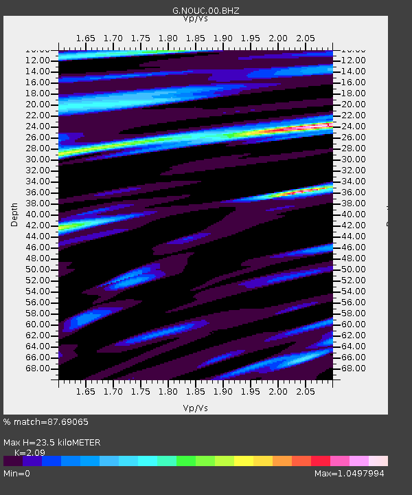
| Estimated Moho Depth: |
23.5 km |
| Estimated Crust Vp/Vs: |
2.09 |
| Assumed Crust Vp: |
5.14 km/s |
| Estimated Crust Vs: |
2.459 km/s |
| Estimated Crust Poisson's Ratio: |
0.35 |
|
| Radial Match: |
87.69065 % |
| Radial Bump: |
400 |
| Transverse Match: |
74.55137 % |
| Transverse Bump: |
400 |
| SOD ConfigId: |
626651 |
| Insert Time: |
2014-04-21 00:05:37.934 +0000 |
| GWidth: |
2.5 |
| Max Bumps: |
400 |
| Tol: |
0.001 |
|
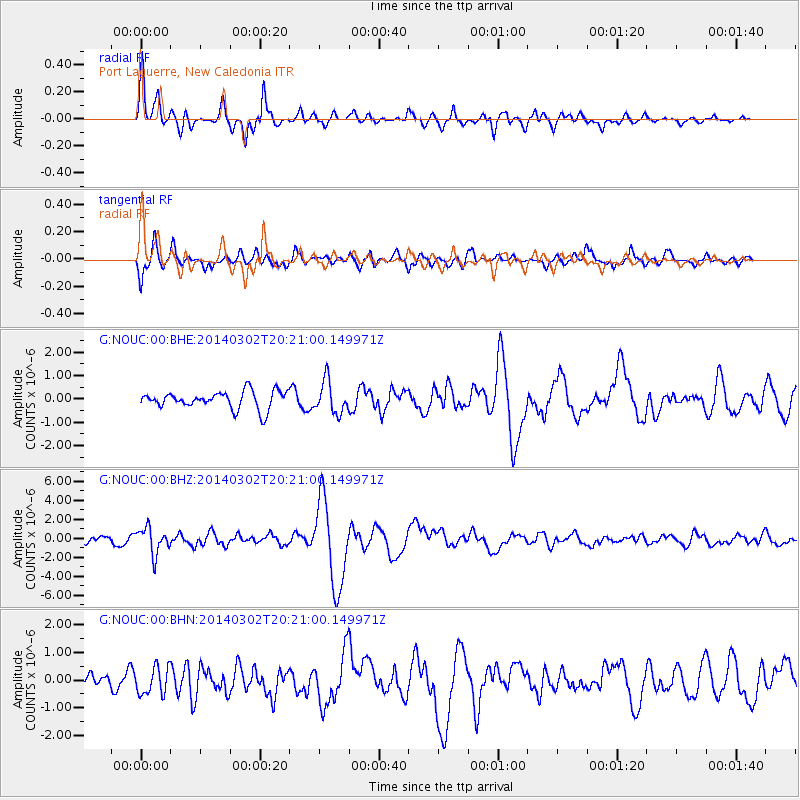
Signal To Noise
| Channel | StoN | STA | LTA |
| G:NOUC:00:BHZ:20140302T20:21:00.149971Z | 3.4475489 | 1.3937313E-6 | 4.042673E-7 |
| G:NOUC:00:BHN:20140302T20:21:00.149971Z | 2.130639 | 4.978862E-7 | 2.3367929E-7 |
| G:NOUC:00:BHE:20140302T20:21:00.149971Z | 1.8285588 | 6.8871526E-7 | 3.7664375E-7 |
| Arrivals |
| Ps | 5.1 SECOND |
| PpPs | 14 SECOND |
| PsPs/PpSs | 19 SECOND |


