You are here: Home > Network List > KR - Kyrgyz Digital Network Stations List
> Station PRZ Karakol, Kyrgyzstan > Earthquake Result Viewer
PRZ Karakol, Kyrgyzstan - Earthquake Result Viewer
| Earthquake location: |
Ryukyu Islands, Japan |
| Earthquake latitude/longitude: |
27.4/127.4 |
| Earthquake time(UTC): |
2014/03/02 (061) 20:11:23 GMT |
| Earthquake Depth: |
119 km |
| Earthquake Magnitude: |
6.5 MWW, 6.4 MWB, 6.5 MWC, 6.6 MI, 6.7 MI |
| Earthquake Catalog/Contributor: |
NEIC PDE/NEIC COMCAT |
|
| Network: |
KR Kyrgyz Digital Network |
| Station: |
PRZ Karakol, Kyrgyzstan |
| Lat/Lon: |
42.47 N/78.40 E |
| Elevation: |
1835 m |
|
| Distance: |
42.3 deg |
| Az: |
303.928 deg |
| Baz: |
94.566 deg |
| Ray Param: |
0.072865345 |
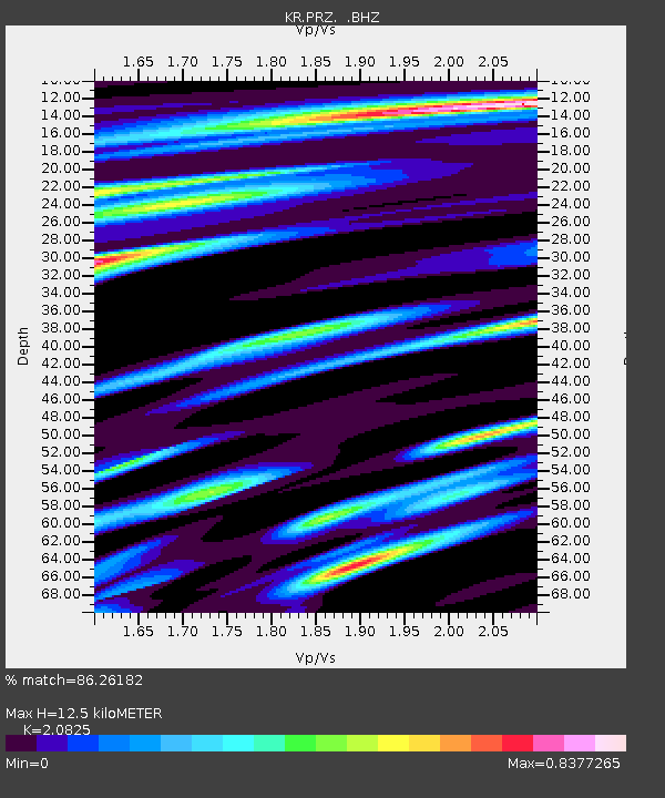
| Estimated Moho Depth: |
12.5 km |
| Estimated Crust Vp/Vs: |
2.08 |
| Assumed Crust Vp: |
6.306 km/s |
| Estimated Crust Vs: |
3.028 km/s |
| Estimated Crust Poisson's Ratio: |
0.35 |
|
| Radial Match: |
86.26182 % |
| Radial Bump: |
400 |
| Transverse Match: |
83.066154 % |
| Transverse Bump: |
400 |
| SOD ConfigId: |
626651 |
| Insert Time: |
2014-04-21 00:11:18.656 +0000 |
| GWidth: |
2.5 |
| Max Bumps: |
400 |
| Tol: |
0.001 |
|

Signal To Noise
| Channel | StoN | STA | LTA |
| KR:PRZ: :BHZ:20140302T20:18:34.650001Z | 63.962112 | 8.208433E-6 | 1.2833276E-7 |
| KR:PRZ: :BHN:20140302T20:18:34.650001Z | 7.844976 | 7.442812E-7 | 9.4873606E-8 |
| KR:PRZ: :BHE:20140302T20:18:34.650001Z | 33.55113 | 2.9175228E-6 | 8.695751E-8 |
| Arrivals |
| Ps | 2.3 SECOND |
| PpPs | 5.8 SECOND |
| PsPs/PpSs | 8.1 SECOND |


