You are here: Home > Network List > GS - US Geological Survey Networks Stations List
> Station KAN13 Rinehart Farm > Earthquake Result Viewer
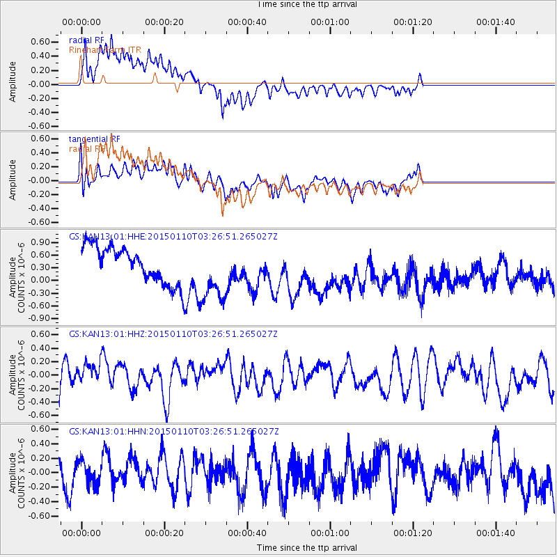
KAN13 Rinehart Farm - Earthquake Result Viewer
*The percent match for this event was below the threshold and hence no stack was calculated.
| Earthquake location: |
Samoa Islands Region |
| Earthquake latitude/longitude: |
-15.9/-172.9 |
| Earthquake time(UTC): |
2015/01/10 (010) 03:14:35 GMT |
| Earthquake Depth: |
44 km |
| Earthquake Magnitude: |
5.1 MW, 5.1 mb, 4.2 MS |
| Earthquake Catalog/Contributor: |
ISC/ISC |
|
| Network: |
GS US Geological Survey Networks |
| Station: |
KAN13 Rinehart Farm |
| Lat/Lon: |
37.01 N/97.48 W |
| Elevation: |
340 m |
|
| Distance: |
88.3 deg |
| Az: |
50.812 deg |
| Baz: |
248.704 deg |
| Ray Param: |
$rayparam |
*The percent match for this event was below the threshold and hence was not used in the summary stack. |
|
| Radial Match: |
64.28981 % |
| Radial Bump: |
400 |
| Transverse Match: |
54.10855 % |
| Transverse Bump: |
400 |
| SOD ConfigId: |
3390531 |
| Insert Time: |
2019-04-16 00:05:08.323 +0000 |
| GWidth: |
2.5 |
| Max Bumps: |
400 |
| Tol: |
0.001 |
|
Signal To Noise
| Channel | StoN | STA | LTA |
| GS:KAN13:01:HHZ:20150110T03:26:51.265027Z | 0.62590677 | 1.6701622E-7 | 2.6683884E-7 |
| GS:KAN13:01:HHN:20150110T03:26:51.265027Z | 0.7449152 | 1.7199191E-7 | 2.3088792E-7 |
| GS:KAN13:01:HHE:20150110T03:26:51.265027Z | 1.6627973 | 7.0664214E-7 | 4.249719E-7 |
| Arrivals |
| Ps | |
| PpPs | |
| PsPs/PpSs | |


