You are here: Home > Network List > GS - US Geological Survey Networks Stations List
> Station OK031 2598 S. Brethren Rd., Cushing, OK, USA > Earthquake Result Viewer
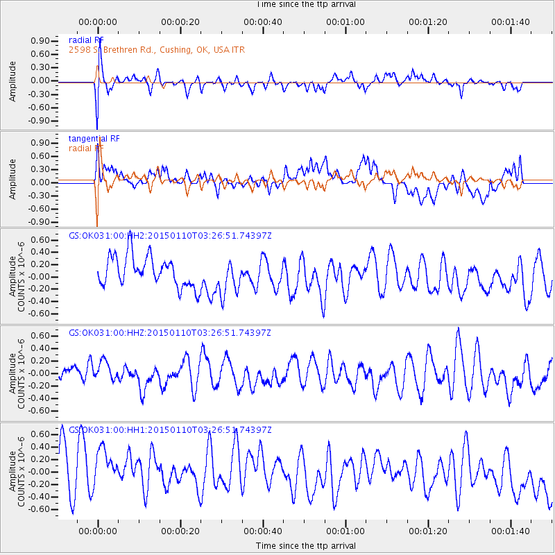
OK031 2598 S. Brethren Rd., Cushing, OK, USA - Earthquake Result Viewer
*The percent match for this event was below the threshold and hence no stack was calculated.
| Earthquake location: |
Samoa Islands Region |
| Earthquake latitude/longitude: |
-15.9/-172.9 |
| Earthquake time(UTC): |
2015/01/10 (010) 03:14:35 GMT |
| Earthquake Depth: |
44 km |
| Earthquake Magnitude: |
5.1 MW, 5.1 mb, 4.2 MS |
| Earthquake Catalog/Contributor: |
ISC/ISC |
|
| Network: |
GS US Geological Survey Networks |
| Station: |
OK031 2598 S. Brethren Rd., Cushing, OK, USA |
| Lat/Lon: |
35.95 N/96.84 W |
| Elevation: |
290 m |
|
| Distance: |
88.4 deg |
| Az: |
51.984 deg |
| Baz: |
249.116 deg |
| Ray Param: |
$rayparam |
*The percent match for this event was below the threshold and hence was not used in the summary stack. |
|
| Radial Match: |
63.306446 % |
| Radial Bump: |
400 |
| Transverse Match: |
42.616425 % |
| Transverse Bump: |
400 |
| SOD ConfigId: |
3390531 |
| Insert Time: |
2019-04-16 00:05:10.087 +0000 |
| GWidth: |
2.5 |
| Max Bumps: |
400 |
| Tol: |
0.001 |
|
Signal To Noise
| Channel | StoN | STA | LTA |
| GS:OK031:00:HHZ:20150110T03:26:51.74397Z | 0.8261353 | 1.5646081E-7 | 1.8938886E-7 |
| GS:OK031:00:HH1:20150110T03:26:51.74397Z | 1.1173514 | 7.461544E-7 | 6.6778847E-7 |
| GS:OK031:00:HH2:20150110T03:26:51.74397Z | 1.1702639 | 2.909495E-7 | 2.486187E-7 |
| Arrivals |
| Ps | |
| PpPs | |
| PsPs/PpSs | |


