You are here: Home > Network List > TJ - Tajikistan National Seismic Network Stations List
> Station SHAA Shaartuz, Tajikistan > Earthquake Result Viewer
SHAA Shaartuz, Tajikistan - Earthquake Result Viewer
| Earthquake location: |
Ryukyu Islands, Japan |
| Earthquake latitude/longitude: |
27.4/127.4 |
| Earthquake time(UTC): |
2014/03/02 (061) 20:11:23 GMT |
| Earthquake Depth: |
119 km |
| Earthquake Magnitude: |
6.5 MWW, 6.4 MWB, 6.5 MWC, 6.6 MI, 6.7 MI |
| Earthquake Catalog/Contributor: |
NEIC PDE/NEIC COMCAT |
|
| Network: |
TJ Tajikistan National Seismic Network |
| Station: |
SHAA Shaartuz, Tajikistan |
| Lat/Lon: |
37.56 N/68.12 E |
| Elevation: |
868 m |
|
| Distance: |
50.3 deg |
| Az: |
297.357 deg |
| Baz: |
83.41 deg |
| Ray Param: |
0.06777091 |
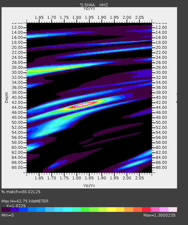
| Estimated Moho Depth: |
42.75 km |
| Estimated Crust Vp/Vs: |
1.82 |
| Assumed Crust Vp: |
6.213 km/s |
| Estimated Crust Vs: |
3.409 km/s |
| Estimated Crust Poisson's Ratio: |
0.28 |
|
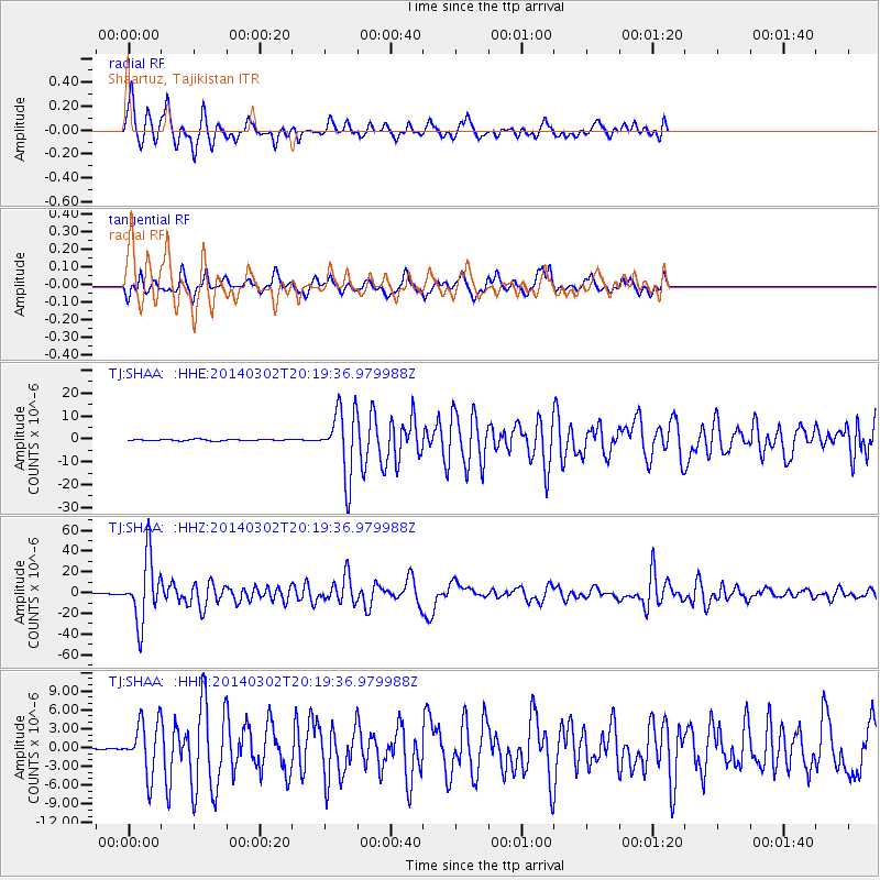
| Radial Match: |
88.02125 % |
| Radial Bump: |
400 |
| Transverse Match: |
79.5424 % |
| Transverse Bump: |
329 |
| SOD ConfigId: |
626651 |
| Insert Time: |
2014-04-21 00:17:27.544 +0000 |
| GWidth: |
2.5 |
| Max Bumps: |
400 |
| Tol: |
0.001 |
|
Signal To Noise
| Channel | StoN | STA | LTA |
| TJ:SHAA: :HHZ:20140302T20:19:36.979988Z | 128.37196 | 3.0487181E-5 | 2.3749095E-7 |
| TJ:SHAA: :HHN:20140302T20:19:36.979988Z | 21.720657 | 4.096027E-6 | 1.8857749E-7 |
| TJ:SHAA: :HHE:20140302T20:19:36.979988Z | 49.641438 | 1.4323677E-5 | 2.8854274E-7 |
| Arrivals |
| Ps | 6.0 SECOND |
| PpPs | 18 SECOND |
| PsPs/PpSs | 24 SECOND |


