You are here: Home > Network List > US - United States National Seismic Network Stations List
> Station DGMT Dagmar, Montana, USA > Earthquake Result Viewer
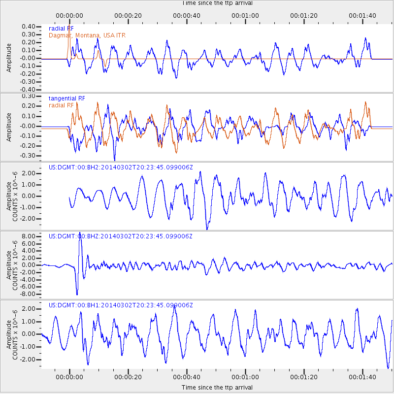
DGMT Dagmar, Montana, USA - Earthquake Result Viewer
*The percent match for this event was below the threshold and hence no stack was calculated.
| Earthquake location: |
Ryukyu Islands, Japan |
| Earthquake latitude/longitude: |
27.4/127.4 |
| Earthquake time(UTC): |
2014/03/02 (061) 20:11:23 GMT |
| Earthquake Depth: |
119 km |
| Earthquake Magnitude: |
6.5 MWW, 6.4 MWB, 6.5 MWC, 6.6 MI, 6.7 MI |
| Earthquake Catalog/Contributor: |
NEIC PDE/NEIC COMCAT |
|
| Network: |
US United States National Seismic Network |
| Station: |
DGMT Dagmar, Montana, USA |
| Lat/Lon: |
48.47 N/104.20 W |
| Elevation: |
0.0 m |
|
| Distance: |
91.5 deg |
| Az: |
31.43 deg |
| Baz: |
315.858 deg |
| Ray Param: |
$rayparam |
*The percent match for this event was below the threshold and hence was not used in the summary stack. |
|
| Radial Match: |
62.46245 % |
| Radial Bump: |
400 |
| Transverse Match: |
41.768982 % |
| Transverse Bump: |
323 |
| SOD ConfigId: |
626651 |
| Insert Time: |
2014-04-21 00:17:43.119 +0000 |
| GWidth: |
2.5 |
| Max Bumps: |
400 |
| Tol: |
0.001 |
|
Signal To Noise
| Channel | StoN | STA | LTA |
| US:DGMT:00:BHZ:20140302T20:23:45.099006Z | 17.682726 | 4.2396878E-6 | 2.3976438E-7 |
| US:DGMT:00:BH1:20140302T20:23:45.099006Z | 1.4121625 | 8.08001E-7 | 5.7217284E-7 |
| US:DGMT:00:BH2:20140302T20:23:45.099006Z | 1.8207549 | 1.1491102E-6 | 6.311175E-7 |
| Arrivals |
| Ps | |
| PpPs | |
| PsPs/PpSs | |


