You are here: Home > Network List > US - United States National Seismic Network Stations List
> Station ELK Elko, Nevada, USA > Earthquake Result Viewer
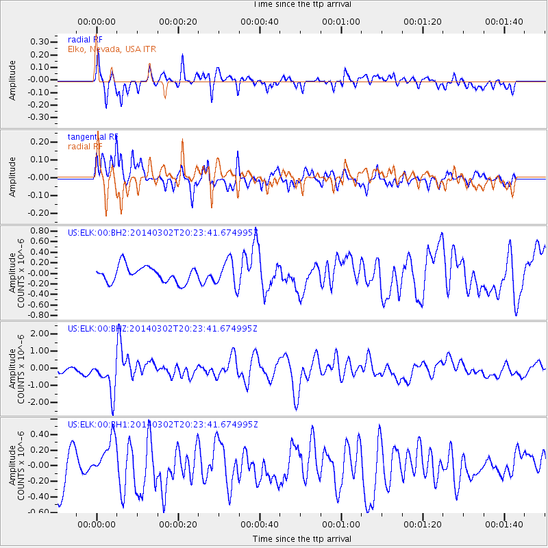
ELK Elko, Nevada, USA - Earthquake Result Viewer
*The percent match for this event was below the threshold and hence no stack was calculated.
| Earthquake location: |
Ryukyu Islands, Japan |
| Earthquake latitude/longitude: |
27.4/127.4 |
| Earthquake time(UTC): |
2014/03/02 (061) 20:11:23 GMT |
| Earthquake Depth: |
119 km |
| Earthquake Magnitude: |
6.5 MWW, 6.4 MWB, 6.5 MWC, 6.6 MI, 6.7 MI |
| Earthquake Catalog/Contributor: |
NEIC PDE/NEIC COMCAT |
|
| Network: |
US United States National Seismic Network |
| Station: |
ELK Elko, Nevada, USA |
| Lat/Lon: |
40.74 N/115.24 W |
| Elevation: |
2210 m |
|
| Distance: |
90.7 deg |
| Az: |
42.426 deg |
| Baz: |
307.887 deg |
| Ray Param: |
$rayparam |
*The percent match for this event was below the threshold and hence was not used in the summary stack. |
|
| Radial Match: |
76.9855 % |
| Radial Bump: |
400 |
| Transverse Match: |
70.265724 % |
| Transverse Bump: |
363 |
| SOD ConfigId: |
626651 |
| Insert Time: |
2014-04-21 00:17:52.158 +0000 |
| GWidth: |
2.5 |
| Max Bumps: |
400 |
| Tol: |
0.001 |
|
Signal To Noise
| Channel | StoN | STA | LTA |
| US:ELK:00:BHZ:20140302T20:23:41.674995Z | 5.2007594 | 1.0121511E-6 | 1.94616E-7 |
| US:ELK:00:BH1:20140302T20:23:41.674995Z | 1.0073924 | 2.7367375E-7 | 2.7166547E-7 |
| US:ELK:00:BH2:20140302T20:23:41.674995Z | 1.7139915 | 2.5794932E-7 | 1.5049626E-7 |
| Arrivals |
| Ps | |
| PpPs | |
| PsPs/PpSs | |


