You are here: Home > Network List > TA - USArray Transportable Network (new EarthScope stations) Stations List
> Station TPFO Pinon Flats, CA, USA > Earthquake Result Viewer
TPFO Pinon Flats, CA, USA - Earthquake Result Viewer
*The percent match for this event was below the threshold and hence no stack was calculated.
| Earthquake location: |
Samoa Islands Region |
| Earthquake latitude/longitude: |
-15.9/-172.9 |
| Earthquake time(UTC): |
2015/01/10 (010) 03:14:35 GMT |
| Earthquake Depth: |
44 km |
| Earthquake Magnitude: |
5.1 MW, 5.1 mb, 4.2 MS |
| Earthquake Catalog/Contributor: |
ISC/ISC |
|
| Network: |
TA USArray Transportable Network (new EarthScope stations) |
| Station: |
TPFO Pinon Flats, CA, USA |
| Lat/Lon: |
33.61 N/116.45 W |
| Elevation: |
1275 m |
|
| Distance: |
72.9 deg |
| Az: |
46.693 deg |
| Baz: |
237.032 deg |
| Ray Param: |
$rayparam |
*The percent match for this event was below the threshold and hence was not used in the summary stack. |
|
| Radial Match: |
75.26196 % |
| Radial Bump: |
337 |
| Transverse Match: |
53.976635 % |
| Transverse Bump: |
326 |
| SOD ConfigId: |
3390531 |
| Insert Time: |
2019-04-16 00:07:41.446 +0000 |
| GWidth: |
2.5 |
| Max Bumps: |
400 |
| Tol: |
0.001 |
|
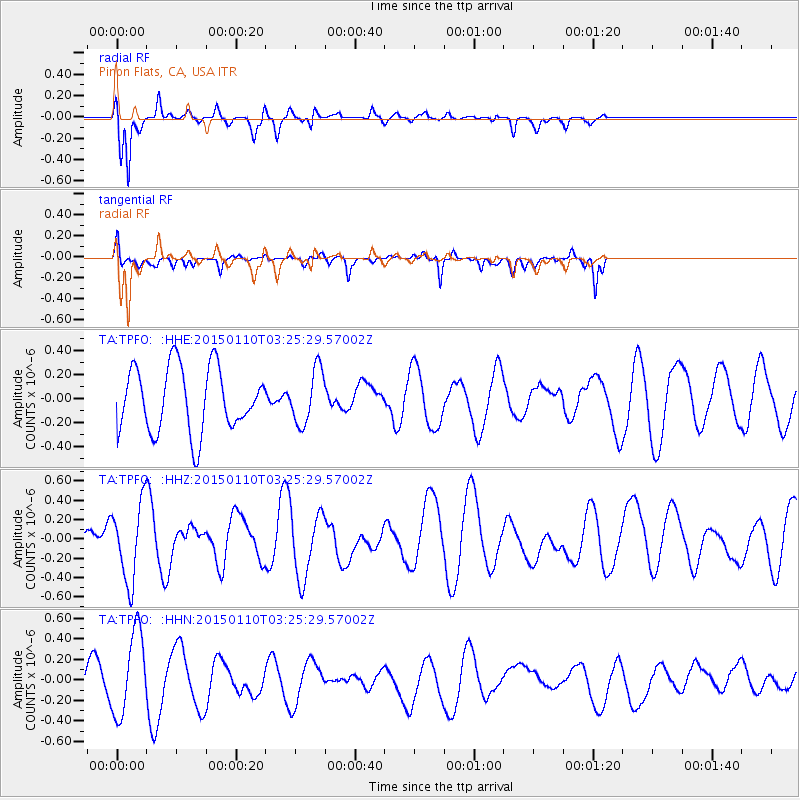
Signal To Noise
| Channel | StoN | STA | LTA |
| TA:TPFO: :HHZ:20150110T03:25:29.57002Z | 1.565318 | 3.9398125E-7 | 2.5169408E-7 |
| TA:TPFO: :HHN:20150110T03:25:29.57002Z | 3.3891342 | 4.1007087E-7 | 1.2099576E-7 |
| TA:TPFO: :HHE:20150110T03:25:29.57002Z | 0.84139824 | 2.2359355E-7 | 2.6574045E-7 |
| Arrivals |
| Ps | |
| PpPs | |
| PsPs/PpSs | |


