You are here: Home > Network List > WY - Yellowstone Wyoming Seismic Network Stations List
> Station YHH Holmes Hill, YNP, WY, USA > Earthquake Result Viewer
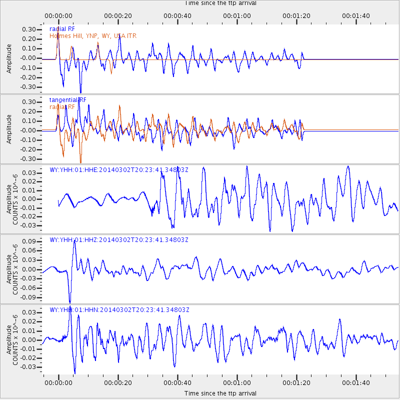
YHH Holmes Hill, YNP, WY, USA - Earthquake Result Viewer
*The percent match for this event was below the threshold and hence no stack was calculated.
| Earthquake location: |
Ryukyu Islands, Japan |
| Earthquake latitude/longitude: |
27.4/127.4 |
| Earthquake time(UTC): |
2014/03/02 (061) 20:11:23 GMT |
| Earthquake Depth: |
119 km |
| Earthquake Magnitude: |
6.5 MWW, 6.4 MWB, 6.5 MWC, 6.6 MI, 6.7 MI |
| Earthquake Catalog/Contributor: |
NEIC PDE/NEIC COMCAT |
|
| Network: |
WY Yellowstone Wyoming Seismic Network |
| Station: |
YHH Holmes Hill, YNP, WY, USA |
| Lat/Lon: |
44.79 N/110.85 W |
| Elevation: |
2717 m |
|
| Distance: |
90.7 deg |
| Az: |
37.254 deg |
| Baz: |
310.922 deg |
| Ray Param: |
$rayparam |
*The percent match for this event was below the threshold and hence was not used in the summary stack. |
|
| Radial Match: |
83.24792 % |
| Radial Bump: |
356 |
| Transverse Match: |
79.1461 % |
| Transverse Bump: |
400 |
| SOD ConfigId: |
626651 |
| Insert Time: |
2014-04-21 00:20:38.951 +0000 |
| GWidth: |
2.5 |
| Max Bumps: |
400 |
| Tol: |
0.001 |
|
Signal To Noise
| Channel | StoN | STA | LTA |
| WY:YHH:01:HHZ:20140302T20:23:41.34803Z | 7.6615605 | 3.7442515E-8 | 4.887061E-9 |
| WY:YHH:01:HHN:20140302T20:23:41.34803Z | 2.188793 | 1.35067175E-8 | 6.1708523E-9 |
| WY:YHH:01:HHE:20140302T20:23:41.34803Z | 3.1701968 | 1.1796499E-8 | 3.721062E-9 |
| Arrivals |
| Ps | |
| PpPs | |
| PsPs/PpSs | |


