You are here: Home > Network List > G - GEOSCOPE Stations List
> Station MPG Montagne des Peres, French Guyana > Earthquake Result Viewer
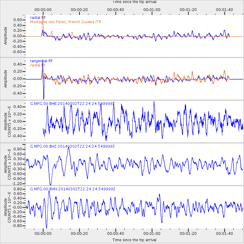
MPG Montagne des Peres, French Guyana - Earthquake Result Viewer
*The percent match for this event was below the threshold and hence no stack was calculated.
| Earthquake location: |
Near Coast Of Chiapas, Mexico |
| Earthquake latitude/longitude: |
14.2/-93.2 |
| Earthquake time(UTC): |
2014/03/02 (061) 22:17:14 GMT |
| Earthquake Depth: |
20 km |
| Earthquake Magnitude: |
6.0 MWC, 6.0 MWC, 6.0 MWW |
| Earthquake Catalog/Contributor: |
NEIC PDE/NEIC COMCAT |
|
| Network: |
G GEOSCOPE |
| Station: |
MPG Montagne des Peres, French Guyana |
| Lat/Lon: |
5.11 N/52.64 W |
| Elevation: |
147 m |
|
| Distance: |
40.9 deg |
| Az: |
98.688 deg |
| Baz: |
285.749 deg |
| Ray Param: |
$rayparam |
*The percent match for this event was below the threshold and hence was not used in the summary stack. |
|
| Radial Match: |
59.670708 % |
| Radial Bump: |
400 |
| Transverse Match: |
55.72693 % |
| Transverse Bump: |
400 |
| SOD ConfigId: |
626651 |
| Insert Time: |
2014-04-21 00:27:56.194 +0000 |
| GWidth: |
2.5 |
| Max Bumps: |
400 |
| Tol: |
0.001 |
|
Signal To Noise
| Channel | StoN | STA | LTA |
| G:MPG:00:BHZ:20140302T22:24:24.549999Z | 2.396683 | 6.3733074E-7 | 2.65922E-7 |
| G:MPG:00:BHN:20140302T22:24:24.549999Z | 3.200757 | 4.6168114E-7 | 1.4424124E-7 |
| G:MPG:00:BHE:20140302T22:24:24.549999Z | 1.3584799 | 2.6470235E-7 | 1.9485188E-7 |
| Arrivals |
| Ps | |
| PpPs | |
| PsPs/PpSs | |


