You are here: Home > Network List > TA - USArray Transportable Network (new EarthScope stations) Stations List
> Station D62A Allapoint, Allagash, ME, USA > Earthquake Result Viewer
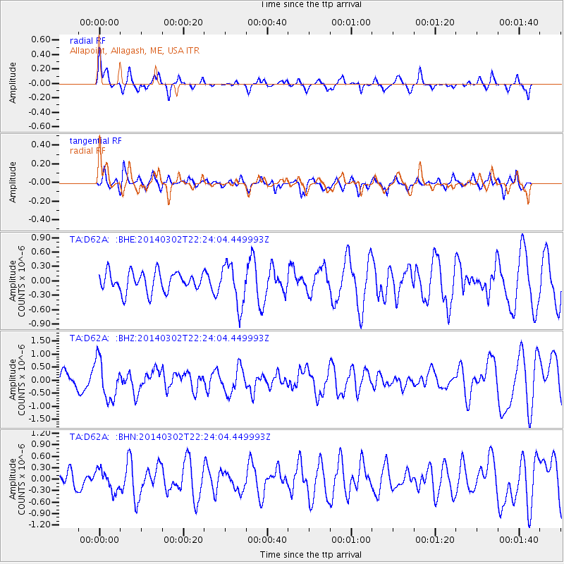
D62A Allapoint, Allagash, ME, USA - Earthquake Result Viewer
*The percent match for this event was below the threshold and hence no stack was calculated.
| Earthquake location: |
Near Coast Of Chiapas, Mexico |
| Earthquake latitude/longitude: |
14.2/-93.2 |
| Earthquake time(UTC): |
2014/03/02 (061) 22:17:14 GMT |
| Earthquake Depth: |
20 km |
| Earthquake Magnitude: |
6.0 MWC, 6.0 MWC, 6.0 MWW |
| Earthquake Catalog/Contributor: |
NEIC PDE/NEIC COMCAT |
|
| Network: |
TA USArray Transportable Network (new EarthScope stations) |
| Station: |
D62A Allapoint, Allagash, ME, USA |
| Lat/Lon: |
47.08 N/69.05 W |
| Elevation: |
189 m |
|
| Distance: |
38.5 deg |
| Az: |
26.658 deg |
| Baz: |
219.546 deg |
| Ray Param: |
$rayparam |
*The percent match for this event was below the threshold and hence was not used in the summary stack. |
|
| Radial Match: |
66.69335 % |
| Radial Bump: |
281 |
| Transverse Match: |
39.854202 % |
| Transverse Bump: |
359 |
| SOD ConfigId: |
626651 |
| Insert Time: |
2014-04-21 00:34:23.448 +0000 |
| GWidth: |
2.5 |
| Max Bumps: |
400 |
| Tol: |
0.001 |
|
Signal To Noise
| Channel | StoN | STA | LTA |
| TA:D62A: :BHZ:20140302T22:24:04.449993Z | 2.0343664 | 7.6911397E-7 | 3.7806072E-7 |
| TA:D62A: :BHN:20140302T22:24:04.449993Z | 1.4066749 | 2.7837407E-7 | 1.978951E-7 |
| TA:D62A: :BHE:20140302T22:24:04.449993Z | 2.1953628 | 4.438752E-7 | 2.0218764E-7 |
| Arrivals |
| Ps | |
| PpPs | |
| PsPs/PpSs | |


