You are here: Home > Network List > TA - USArray Transportable Network (new EarthScope stations) Stations List
> Station I48A Sherman Twp, MI, USA > Earthquake Result Viewer
I48A Sherman Twp, MI, USA - Earthquake Result Viewer
*The percent match for this event was below the threshold and hence no stack was calculated.
| Earthquake location: |
Near Coast Of Chiapas, Mexico |
| Earthquake latitude/longitude: |
14.2/-93.2 |
| Earthquake time(UTC): |
2014/03/02 (061) 22:17:14 GMT |
| Earthquake Depth: |
20 km |
| Earthquake Magnitude: |
6.0 MWC, 6.0 MWC, 6.0 MWW |
| Earthquake Catalog/Contributor: |
NEIC PDE/NEIC COMCAT |
|
| Network: |
TA USArray Transportable Network (new EarthScope stations) |
| Station: |
I48A Sherman Twp, MI, USA |
| Lat/Lon: |
44.19 N/83.70 W |
| Elevation: |
192 m |
|
| Distance: |
31.0 deg |
| Az: |
13.276 deg |
| Baz: |
198.033 deg |
| Ray Param: |
$rayparam |
*The percent match for this event was below the threshold and hence was not used in the summary stack. |
|
| Radial Match: |
64.49501 % |
| Radial Bump: |
400 |
| Transverse Match: |
51.984737 % |
| Transverse Bump: |
359 |
| SOD ConfigId: |
626651 |
| Insert Time: |
2014-04-21 00:36:15.209 +0000 |
| GWidth: |
2.5 |
| Max Bumps: |
400 |
| Tol: |
0.001 |
|
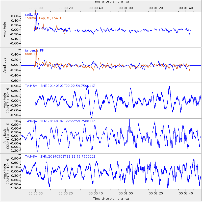
Signal To Noise
| Channel | StoN | STA | LTA |
| TA:I48A: :BHZ:20140302T22:22:59.750011Z | 3.1646204 | 6.894055E-7 | 2.1784778E-7 |
| TA:I48A: :BHN:20140302T22:22:59.750011Z | 1.1710942 | 3.7764153E-7 | 3.2246896E-7 |
| TA:I48A: :BHE:20140302T22:22:59.750011Z | 2.2272255 | 4.700702E-7 | 2.110564E-7 |
| Arrivals |
| Ps | |
| PpPs | |
| PsPs/PpSs | |


