You are here: Home > Network List > AZ - ANZA Regional Network Stations List
> Station LVA2 AZ.LVA2 > Earthquake Result Viewer
LVA2 AZ.LVA2 - Earthquake Result Viewer
*The percent match for this event was below the threshold and hence no stack was calculated.
| Earthquake location: |
Chile-Bolivia Border Region |
| Earthquake latitude/longitude: |
-21.6/-68.5 |
| Earthquake time(UTC): |
2015/01/10 (010) 17:55:02 GMT |
| Earthquake Depth: |
109 km |
| Earthquake Magnitude: |
5.5 MWW, 5.4 MWR, 5.5 MWB |
| Earthquake Catalog/Contributor: |
NEIC PDE/NEIC COMCAT |
|
| Network: |
AZ ANZA Regional Network |
| Station: |
LVA2 AZ.LVA2 |
| Lat/Lon: |
33.35 N/116.56 W |
| Elevation: |
1435 m |
|
| Distance: |
71.3 deg |
| Az: |
318.938 deg |
| Baz: |
133.098 deg |
| Ray Param: |
$rayparam |
*The percent match for this event was below the threshold and hence was not used in the summary stack. |
|
| Radial Match: |
38.299286 % |
| Radial Bump: |
400 |
| Transverse Match: |
45.55442 % |
| Transverse Bump: |
400 |
| SOD ConfigId: |
3390531 |
| Insert Time: |
2019-04-16 00:17:20.123 +0000 |
| GWidth: |
2.5 |
| Max Bumps: |
400 |
| Tol: |
0.001 |
|
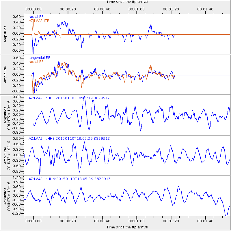
Signal To Noise
| Channel | StoN | STA | LTA |
| AZ:LVA2: :HHZ:20150110T18:05:39.382991Z | 3.1691916 | 4.1904866E-7 | 1.3222572E-7 |
| AZ:LVA2: :HHN:20150110T18:05:39.382991Z | 0.47603154 | 1.3098233E-7 | 2.7515472E-7 |
| AZ:LVA2: :HHE:20150110T18:05:39.382991Z | 2.655171 | 5.5472714E-7 | 2.0892334E-7 |
| Arrivals |
| Ps | |
| PpPs | |
| PsPs/PpSs | |


