You are here: Home > Network List > US - United States National Seismic Network Stations List
> Station HAWA Hanford, Washington, USA > Earthquake Result Viewer
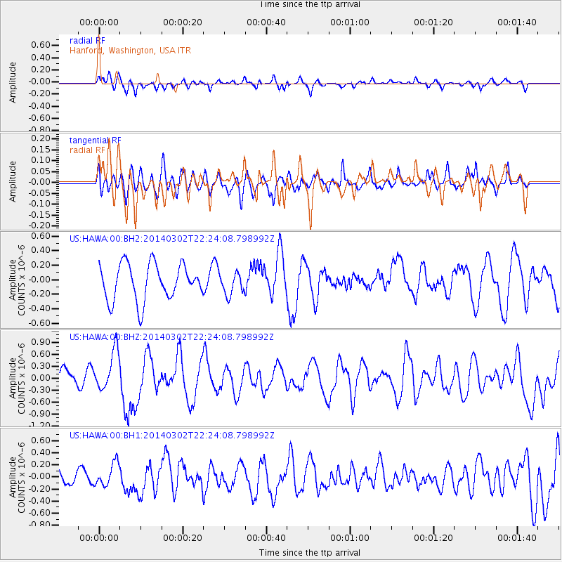
HAWA Hanford, Washington, USA - Earthquake Result Viewer
*The percent match for this event was below the threshold and hence no stack was calculated.
| Earthquake location: |
Near Coast Of Chiapas, Mexico |
| Earthquake latitude/longitude: |
14.2/-93.2 |
| Earthquake time(UTC): |
2014/03/02 (061) 22:17:14 GMT |
| Earthquake Depth: |
20 km |
| Earthquake Magnitude: |
6.0 MWC, 6.0 MWC, 6.0 MWW |
| Earthquake Catalog/Contributor: |
NEIC PDE/NEIC COMCAT |
|
| Network: |
US United States National Seismic Network |
| Station: |
HAWA Hanford, Washington, USA |
| Lat/Lon: |
46.39 N/119.53 W |
| Elevation: |
364 m |
|
| Distance: |
39.0 deg |
| Az: |
330.733 deg |
| Baz: |
136.763 deg |
| Ray Param: |
$rayparam |
*The percent match for this event was below the threshold and hence was not used in the summary stack. |
|
| Radial Match: |
45.459972 % |
| Radial Bump: |
400 |
| Transverse Match: |
58.800037 % |
| Transverse Bump: |
400 |
| SOD ConfigId: |
626651 |
| Insert Time: |
2014-04-21 00:39:09.573 +0000 |
| GWidth: |
2.5 |
| Max Bumps: |
400 |
| Tol: |
0.001 |
|
Signal To Noise
| Channel | StoN | STA | LTA |
| US:HAWA:00:BHZ:20140302T22:24:08.798992Z | 2.3234015 | 5.1788584E-7 | 2.2289986E-7 |
| US:HAWA:00:BH1:20140302T22:24:08.798992Z | 0.72703844 | 1.9079695E-7 | 2.6243035E-7 |
| US:HAWA:00:BH2:20140302T22:24:08.798992Z | 0.5972631 | 1.4836995E-7 | 2.484164E-7 |
| Arrivals |
| Ps | |
| PpPs | |
| PsPs/PpSs | |


