You are here: Home > Network List > UW - Pacific Northwest Regional Seismic Network Stations List
> Station MRBL Marblemount, WA, USA > Earthquake Result Viewer
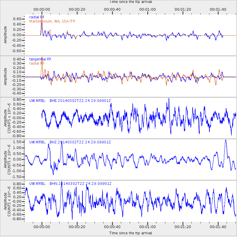
MRBL Marblemount, WA, USA - Earthquake Result Viewer
*The percent match for this event was below the threshold and hence no stack was calculated.
| Earthquake location: |
Near Coast Of Chiapas, Mexico |
| Earthquake latitude/longitude: |
14.2/-93.2 |
| Earthquake time(UTC): |
2014/03/02 (061) 22:17:14 GMT |
| Earthquake Depth: |
20 km |
| Earthquake Magnitude: |
6.0 MWC, 6.0 MWC, 6.0 MWW |
| Earthquake Catalog/Contributor: |
NEIC PDE/NEIC COMCAT |
|
| Network: |
UW Pacific Northwest Regional Seismic Network |
| Station: |
MRBL Marblemount, WA, USA |
| Lat/Lon: |
48.52 N/121.48 W |
| Elevation: |
75 m |
|
| Distance: |
41.4 deg |
| Az: |
331.522 deg |
| Baz: |
135.932 deg |
| Ray Param: |
$rayparam |
*The percent match for this event was below the threshold and hence was not used in the summary stack. |
|
| Radial Match: |
56.42467 % |
| Radial Bump: |
400 |
| Transverse Match: |
74.10593 % |
| Transverse Bump: |
400 |
| SOD ConfigId: |
626651 |
| Insert Time: |
2014-04-21 00:40:14.318 +0000 |
| GWidth: |
2.5 |
| Max Bumps: |
400 |
| Tol: |
0.001 |
|
Signal To Noise
| Channel | StoN | STA | LTA |
| UW:MRBL: :BHZ:20140302T22:24:29.09901Z | 2.6208766 | 5.5046064E-7 | 2.1002923E-7 |
| UW:MRBL: :BHN:20140302T22:24:29.09901Z | 1.0452092 | 2.557411E-7 | 2.4467934E-7 |
| UW:MRBL: :BHE:20140302T22:24:29.09901Z | 0.89616954 | 1.8472417E-7 | 2.0612637E-7 |
| Arrivals |
| Ps | |
| PpPs | |
| PsPs/PpSs | |


