You are here: Home > Network List > TA - USArray Transportable Network (new EarthScope stations) Stations List
> Station D46A Sault St. Marie, ON, CAN > Earthquake Result Viewer
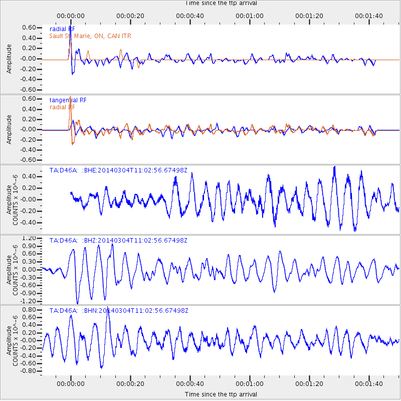
D46A Sault St. Marie, ON, CAN - Earthquake Result Viewer
*The percent match for this event was below the threshold and hence no stack was calculated.
| Earthquake location: |
Near Coast Of Central Chile |
| Earthquake latitude/longitude: |
-33.6/-72.0 |
| Earthquake time(UTC): |
2014/03/04 (063) 10:51:15 GMT |
| Earthquake Depth: |
20 km |
| Earthquake Magnitude: |
5.7 MWW, 5.7 MWB, 5.8 MWC |
| Earthquake Catalog/Contributor: |
NEIC PDE/NEIC COMCAT |
|
| Network: |
TA USArray Transportable Network (new EarthScope stations) |
| Station: |
D46A Sault St. Marie, ON, CAN |
| Lat/Lon: |
46.89 N/84.04 W |
| Elevation: |
353 m |
|
| Distance: |
80.9 deg |
| Az: |
351.642 deg |
| Baz: |
169.812 deg |
| Ray Param: |
$rayparam |
*The percent match for this event was below the threshold and hence was not used in the summary stack. |
|
| Radial Match: |
66.13785 % |
| Radial Bump: |
400 |
| Transverse Match: |
74.05767 % |
| Transverse Bump: |
400 |
| SOD ConfigId: |
626651 |
| Insert Time: |
2014-04-21 00:54:11.095 +0000 |
| GWidth: |
2.5 |
| Max Bumps: |
400 |
| Tol: |
0.001 |
|
Signal To Noise
| Channel | StoN | STA | LTA |
| TA:D46A: :BHZ:20140304T11:02:56.67498Z | 5.120347 | 6.9757243E-7 | 1.3623539E-7 |
| TA:D46A: :BHN:20140304T11:02:56.67498Z | 1.6151955 | 3.617707E-7 | 2.2397951E-7 |
| TA:D46A: :BHE:20140304T11:02:56.67498Z | 1.6730728 | 1.5142518E-7 | 9.050723E-8 |
| Arrivals |
| Ps | |
| PpPs | |
| PsPs/PpSs | |


