You are here: Home > Network List > TA - USArray Transportable Network (new EarthScope stations) Stations List
> Station J45A Montague, MI, USA > Earthquake Result Viewer
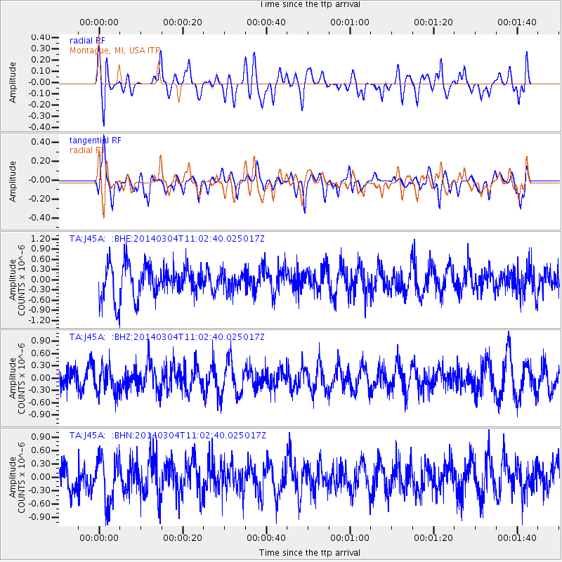
J45A Montague, MI, USA - Earthquake Result Viewer
*The percent match for this event was below the threshold and hence no stack was calculated.
| Earthquake location: |
Near Coast Of Central Chile |
| Earthquake latitude/longitude: |
-33.6/-72.0 |
| Earthquake time(UTC): |
2014/03/04 (063) 10:51:15 GMT |
| Earthquake Depth: |
20 km |
| Earthquake Magnitude: |
5.7 MWW, 5.7 MWB, 5.8 MWC |
| Earthquake Catalog/Contributor: |
NEIC PDE/NEIC COMCAT |
|
| Network: |
TA USArray Transportable Network (new EarthScope stations) |
| Station: |
J45A Montague, MI, USA |
| Lat/Lon: |
43.44 N/86.39 W |
| Elevation: |
209 m |
|
| Distance: |
77.8 deg |
| Az: |
349.295 deg |
| Baz: |
167.713 deg |
| Ray Param: |
$rayparam |
*The percent match for this event was below the threshold and hence was not used in the summary stack. |
|
| Radial Match: |
45.527313 % |
| Radial Bump: |
400 |
| Transverse Match: |
58.76554 % |
| Transverse Bump: |
400 |
| SOD ConfigId: |
626651 |
| Insert Time: |
2014-04-21 00:56:32.502 +0000 |
| GWidth: |
2.5 |
| Max Bumps: |
400 |
| Tol: |
0.001 |
|
Signal To Noise
| Channel | StoN | STA | LTA |
| TA:J45A: :BHZ:20140304T11:02:40.025017Z | 1.3047493 | 3.1641528E-7 | 2.4251042E-7 |
| TA:J45A: :BHN:20140304T11:02:40.025017Z | 2.0620463 | 5.166763E-7 | 2.5056485E-7 |
| TA:J45A: :BHE:20140304T11:02:40.025017Z | 0.5529449 | 2.5909023E-7 | 4.6856425E-7 |
| Arrivals |
| Ps | |
| PpPs | |
| PsPs/PpSs | |


