You are here: Home > Network List > TA - USArray Transportable Network (new EarthScope stations) Stations List
> Station M47A Cromwell, IN, USA > Earthquake Result Viewer
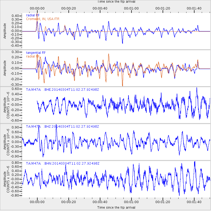
M47A Cromwell, IN, USA - Earthquake Result Viewer
*The percent match for this event was below the threshold and hence no stack was calculated.
| Earthquake location: |
Near Coast Of Central Chile |
| Earthquake latitude/longitude: |
-33.6/-72.0 |
| Earthquake time(UTC): |
2014/03/04 (063) 10:51:15 GMT |
| Earthquake Depth: |
20 km |
| Earthquake Magnitude: |
5.7 MWW, 5.7 MWB, 5.8 MWC |
| Earthquake Catalog/Contributor: |
NEIC PDE/NEIC COMCAT |
|
| Network: |
TA USArray Transportable Network (new EarthScope stations) |
| Station: |
M47A Cromwell, IN, USA |
| Lat/Lon: |
41.36 N/85.62 W |
| Elevation: |
283 m |
|
| Distance: |
75.7 deg |
| Az: |
349.423 deg |
| Baz: |
168.258 deg |
| Ray Param: |
$rayparam |
*The percent match for this event was below the threshold and hence was not used in the summary stack. |
|
| Radial Match: |
70.01831 % |
| Radial Bump: |
400 |
| Transverse Match: |
61.0061 % |
| Transverse Bump: |
400 |
| SOD ConfigId: |
626651 |
| Insert Time: |
2014-04-21 00:57:55.045 +0000 |
| GWidth: |
2.5 |
| Max Bumps: |
400 |
| Tol: |
0.001 |
|
Signal To Noise
| Channel | StoN | STA | LTA |
| TA:M47A: :BHZ:20140304T11:02:27.92498Z | 2.2680507 | 4.926506E-7 | 2.1721324E-7 |
| TA:M47A: :BHN:20140304T11:02:27.92498Z | 1.1813042 | 2.351892E-7 | 1.9909282E-7 |
| TA:M47A: :BHE:20140304T11:02:27.92498Z | 1.3588544 | 2.2182478E-7 | 1.6324395E-7 |
| Arrivals |
| Ps | |
| PpPs | |
| PsPs/PpSs | |


