You are here: Home > Network List > TA - USArray Transportable Network (new EarthScope stations) Stations List
> Station MDND Maddock, ND, USA > Earthquake Result Viewer
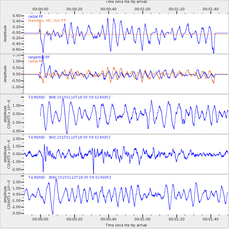
MDND Maddock, ND, USA - Earthquake Result Viewer
*The percent match for this event was below the threshold and hence no stack was calculated.
| Earthquake location: |
Chile-Bolivia Border Region |
| Earthquake latitude/longitude: |
-21.6/-68.5 |
| Earthquake time(UTC): |
2015/01/10 (010) 17:55:02 GMT |
| Earthquake Depth: |
109 km |
| Earthquake Magnitude: |
5.5 MWW, 5.4 MWR, 5.5 MWB |
| Earthquake Catalog/Contributor: |
NEIC PDE/NEIC COMCAT |
|
| Network: |
TA USArray Transportable Network (new EarthScope stations) |
| Station: |
MDND Maddock, ND, USA |
| Lat/Lon: |
47.85 N/99.60 W |
| Elevation: |
479 m |
|
| Distance: |
74.6 deg |
| Az: |
338.863 deg |
| Baz: |
150.127 deg |
| Ray Param: |
$rayparam |
*The percent match for this event was below the threshold and hence was not used in the summary stack. |
|
| Radial Match: |
49.94548 % |
| Radial Bump: |
400 |
| Transverse Match: |
74.270615 % |
| Transverse Bump: |
400 |
| SOD ConfigId: |
3390531 |
| Insert Time: |
2019-04-16 00:21:56.278 +0000 |
| GWidth: |
2.5 |
| Max Bumps: |
400 |
| Tol: |
0.001 |
|
Signal To Noise
| Channel | StoN | STA | LTA |
| TA:MDND: :BHZ:20150110T18:05:58.624995Z | 2.1506186 | 7.33075E-7 | 3.4086705E-7 |
| TA:MDND: :BHN:20150110T18:05:58.624995Z | 1.548248 | 9.523106E-7 | 6.150892E-7 |
| TA:MDND: :BHE:20150110T18:05:58.624995Z | 0.8475292 | 8.23563E-7 | 9.717223E-7 |
| Arrivals |
| Ps | |
| PpPs | |
| PsPs/PpSs | |


