You are here: Home > Network List > TA - USArray Transportable Network (new EarthScope stations) Stations List
> Station Q24A Divide, CO, USA > Earthquake Result Viewer
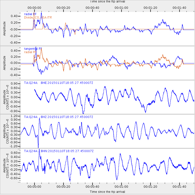
Q24A Divide, CO, USA - Earthquake Result Viewer
*The percent match for this event was below the threshold and hence no stack was calculated.
| Earthquake location: |
Chile-Bolivia Border Region |
| Earthquake latitude/longitude: |
-21.6/-68.5 |
| Earthquake time(UTC): |
2015/01/10 (010) 17:55:02 GMT |
| Earthquake Depth: |
109 km |
| Earthquake Magnitude: |
5.5 MWW, 5.4 MWR, 5.5 MWB |
| Earthquake Catalog/Contributor: |
NEIC PDE/NEIC COMCAT |
|
| Network: |
TA USArray Transportable Network (new EarthScope stations) |
| Station: |
Q24A Divide, CO, USA |
| Lat/Lon: |
38.96 N/105.15 W |
| Elevation: |
2775 m |
|
| Distance: |
69.3 deg |
| Az: |
330.204 deg |
| Baz: |
143.627 deg |
| Ray Param: |
$rayparam |
*The percent match for this event was below the threshold and hence was not used in the summary stack. |
|
| Radial Match: |
48.209133 % |
| Radial Bump: |
400 |
| Transverse Match: |
62.535625 % |
| Transverse Bump: |
400 |
| SOD ConfigId: |
3390531 |
| Insert Time: |
2019-04-16 00:22:02.032 +0000 |
| GWidth: |
2.5 |
| Max Bumps: |
400 |
| Tol: |
0.001 |
|
Signal To Noise
| Channel | StoN | STA | LTA |
| TA:Q24A: :BHZ:20150110T18:05:27.450007Z | 2.9459035 | 5.2855876E-7 | 1.7942162E-7 |
| TA:Q24A: :BHN:20150110T18:05:27.450007Z | 2.89015 | 3.1984797E-7 | 1.10668296E-7 |
| TA:Q24A: :BHE:20150110T18:05:27.450007Z | 2.9202354 | 6.245462E-7 | 2.1386845E-7 |
| Arrivals |
| Ps | |
| PpPs | |
| PsPs/PpSs | |


