You are here: Home > Network List > TA - USArray Transportable Network (new EarthScope stations) Stations List
> Station R11A Troy Canyon, Currant, NV, USA > Earthquake Result Viewer
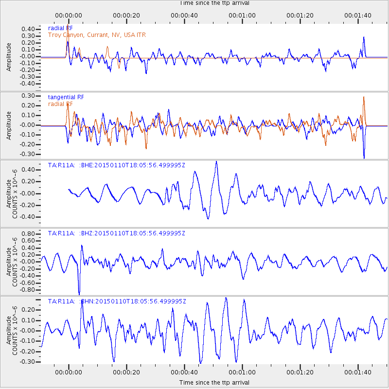
R11A Troy Canyon, Currant, NV, USA - Earthquake Result Viewer
*The percent match for this event was below the threshold and hence no stack was calculated.
| Earthquake location: |
Chile-Bolivia Border Region |
| Earthquake latitude/longitude: |
-21.6/-68.5 |
| Earthquake time(UTC): |
2015/01/10 (010) 17:55:02 GMT |
| Earthquake Depth: |
109 km |
| Earthquake Magnitude: |
5.5 MWW, 5.4 MWR, 5.5 MWB |
| Earthquake Catalog/Contributor: |
NEIC PDE/NEIC COMCAT |
|
| Network: |
TA USArray Transportable Network (new EarthScope stations) |
| Station: |
R11A Troy Canyon, Currant, NV, USA |
| Lat/Lon: |
38.35 N/115.59 W |
| Elevation: |
1756 m |
|
| Distance: |
74.2 deg |
| Az: |
323.268 deg |
| Baz: |
134.952 deg |
| Ray Param: |
$rayparam |
*The percent match for this event was below the threshold and hence was not used in the summary stack. |
|
| Radial Match: |
45.94676 % |
| Radial Bump: |
400 |
| Transverse Match: |
31.498571 % |
| Transverse Bump: |
400 |
| SOD ConfigId: |
3390531 |
| Insert Time: |
2019-04-16 00:22:03.464 +0000 |
| GWidth: |
2.5 |
| Max Bumps: |
400 |
| Tol: |
0.001 |
|
Signal To Noise
| Channel | StoN | STA | LTA |
| TA:R11A: :BHZ:20150110T18:05:56.499995Z | 3.340496 | 3.287629E-7 | 9.841739E-8 |
| TA:R11A: :BHN:20150110T18:05:56.499995Z | 1.3961076 | 1.18605854E-7 | 8.495467E-8 |
| TA:R11A: :BHE:20150110T18:05:56.499995Z | 1.1168746 | 9.419567E-8 | 8.433863E-8 |
| Arrivals |
| Ps | |
| PpPs | |
| PsPs/PpSs | |


