You are here: Home > Network List > US - United States National Seismic Network Stations List
> Station DGMT Dagmar, Montana, USA > Earthquake Result Viewer
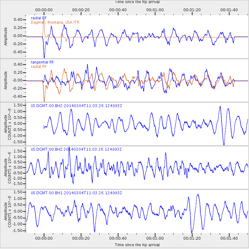
DGMT Dagmar, Montana, USA - Earthquake Result Viewer
*The percent match for this event was below the threshold and hence no stack was calculated.
| Earthquake location: |
Near Coast Of Central Chile |
| Earthquake latitude/longitude: |
-33.6/-72.0 |
| Earthquake time(UTC): |
2014/03/04 (063) 10:51:15 GMT |
| Earthquake Depth: |
20 km |
| Earthquake Magnitude: |
5.7 MWW, 5.7 MWB, 5.8 MWC |
| Earthquake Catalog/Contributor: |
NEIC PDE/NEIC COMCAT |
|
| Network: |
US United States National Seismic Network |
| Station: |
DGMT Dagmar, Montana, USA |
| Lat/Lon: |
48.47 N/104.20 W |
| Elevation: |
0.0 m |
|
| Distance: |
86.6 deg |
| Az: |
339.169 deg |
| Baz: |
153.515 deg |
| Ray Param: |
$rayparam |
*The percent match for this event was below the threshold and hence was not used in the summary stack. |
|
| Radial Match: |
54.27507 % |
| Radial Bump: |
400 |
| Transverse Match: |
55.381668 % |
| Transverse Bump: |
400 |
| SOD ConfigId: |
626651 |
| Insert Time: |
2014-04-21 01:01:50.202 +0000 |
| GWidth: |
2.5 |
| Max Bumps: |
400 |
| Tol: |
0.001 |
|
Signal To Noise
| Channel | StoN | STA | LTA |
| US:DGMT:00:BHZ:20140304T11:03:26.124993Z | 1.8614413 | 5.724899E-7 | 3.0755197E-7 |
| US:DGMT:00:BH1:20140304T11:03:26.124993Z | 0.76596826 | 3.7036514E-7 | 4.835254E-7 |
| US:DGMT:00:BH2:20140304T11:03:26.124993Z | 0.28730175 | 1.6084178E-7 | 5.598357E-7 |
| Arrivals |
| Ps | |
| PpPs | |
| PsPs/PpSs | |


