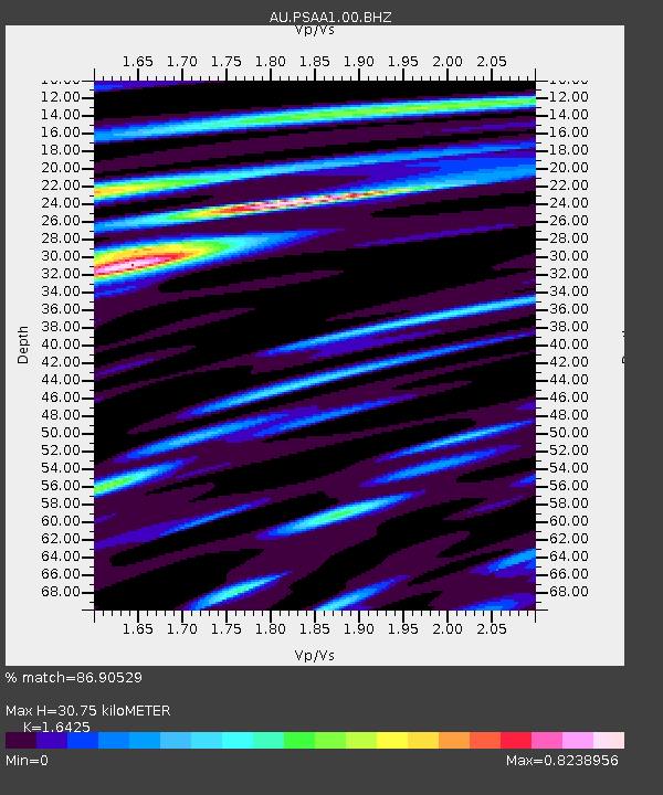
PSAA1 Pilbara Seismic Array Element A1 - Earthquake Result Viewer

Earthquake location: Vanuatu Islands
Earthquake latitude/longitude: -14.7/169.8
Earthquake time(UTC): 2014/03/05 (064) 09:56:57 GMT
Earthquake Depth: 638 km
Earthquake Magnitude: 6.3 MWW, 6.3 MWC, 6.4 MWC, 6.4 MWB
Earthquake Catalog/Contributor: NEIC PDE/NEIC COMCAT
Network: AU Australian Seismological Centre
Station: PSAA1 Pilbara Seismic Array Element A1
Lat/Lon: 21.58 S/119.84 E
Elevation: 325 m
Distance: 47.8 deg
Az: 254.146 deg
Baz: 90.608 deg
Ray Param: 0.06660597
Estimated Moho Depth: 30.75 km
Estimated Crust Vp/Vs: 1.64
Assumed Crust Vp: 6.464 km/s
Estimated Crust Vs: 3.935 km/s
Estimated Crust Poisson's Ratio: 0.21
Radial Match: 86.90529 %
Radial Bump: 400
Transverse Match: 70.16144 %
Transverse Bump: 400
SOD ConfigId: 626651
Insert Time: 2014-04-21 01:11:00.131 +0000
GWidth: 2.5
Max Bumps: 400
Tol: 0.001

Signal To Noise

ChannelStoNSTALTA
AU:PSAA1:00:BHZ:20140305T10:04:09.29401Z17.940634.8168354E-62.6848753E-7
AU:PSAA1:00:BH1:20140305T10:04:09.29401Z2.77814636.391079E-72.3004833E-7
AU:PSAA1:00:BH2:20140305T10:04:09.29401Z9.3074782.7136427E-62.9155512E-7
Arrivals
Ps3.2 SECOND
PpPs12 SECOND
PsPs/PpSs15 SECOND