You are here: Home > Network List > TA - USArray Transportable Network (new EarthScope stations) Stations List
> Station G05D Wamic, OR, USA > Earthquake Result Viewer
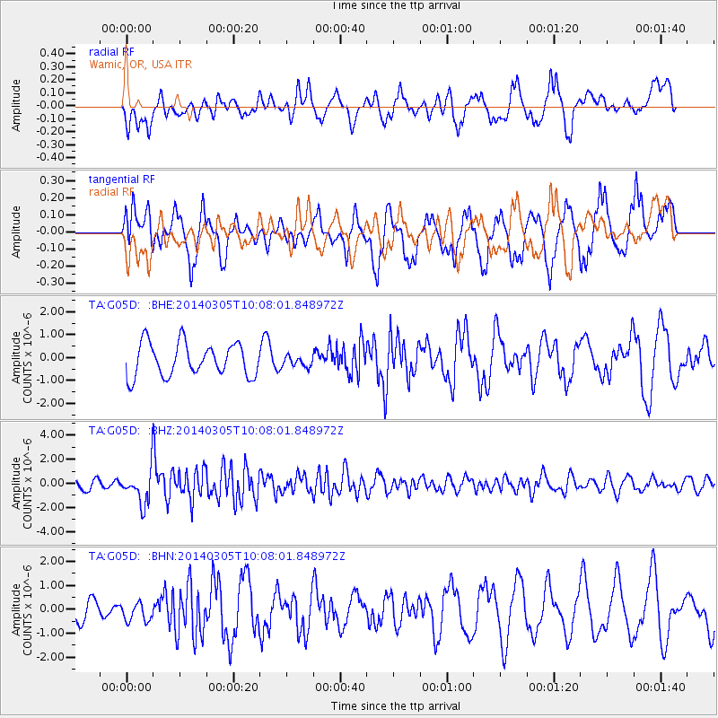
G05D Wamic, OR, USA - Earthquake Result Viewer
*The percent match for this event was below the threshold and hence no stack was calculated.
| Earthquake location: |
Vanuatu Islands |
| Earthquake latitude/longitude: |
-14.7/169.8 |
| Earthquake time(UTC): |
2014/03/05 (064) 09:56:57 GMT |
| Earthquake Depth: |
638 km |
| Earthquake Magnitude: |
6.3 MWW, 6.3 MWC, 6.4 MWC, 6.4 MWB |
| Earthquake Catalog/Contributor: |
NEIC PDE/NEIC COMCAT |
|
| Network: |
TA USArray Transportable Network (new EarthScope stations) |
| Station: |
G05D Wamic, OR, USA |
| Lat/Lon: |
45.24 N/121.32 W |
| Elevation: |
592 m |
|
| Distance: |
86.1 deg |
| Az: |
41.335 deg |
| Baz: |
244.753 deg |
| Ray Param: |
$rayparam |
*The percent match for this event was below the threshold and hence was not used in the summary stack. |
|
| Radial Match: |
58.04056 % |
| Radial Bump: |
400 |
| Transverse Match: |
73.73866 % |
| Transverse Bump: |
400 |
| SOD ConfigId: |
626651 |
| Insert Time: |
2014-04-21 01:23:16.788 +0000 |
| GWidth: |
2.5 |
| Max Bumps: |
400 |
| Tol: |
0.001 |
|
Signal To Noise
| Channel | StoN | STA | LTA |
| TA:G05D: :BHZ:20140305T10:08:01.848972Z | 1.9880847 | 1.4440324E-6 | 7.263435E-7 |
| TA:G05D: :BHN:20140305T10:08:01.848972Z | 0.6380487 | 3.9295975E-7 | 6.158773E-7 |
| TA:G05D: :BHE:20140305T10:08:01.848972Z | 0.3239062 | 2.3308407E-7 | 7.196036E-7 |
| Arrivals |
| Ps | |
| PpPs | |
| PsPs/PpSs | |


