You are here: Home > Network List > UW - Pacific Northwest Regional Seismic Network Stations List
> Station LEBA Lebam, WA, USA > Earthquake Result Viewer
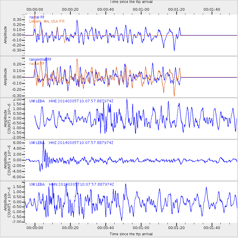
LEBA Lebam, WA, USA - Earthquake Result Viewer
*The percent match for this event was below the threshold and hence no stack was calculated.
| Earthquake location: |
Vanuatu Islands |
| Earthquake latitude/longitude: |
-14.7/169.8 |
| Earthquake time(UTC): |
2014/03/05 (064) 09:56:57 GMT |
| Earthquake Depth: |
638 km |
| Earthquake Magnitude: |
6.3 MWW, 6.3 MWC, 6.4 MWC, 6.4 MWB |
| Earthquake Catalog/Contributor: |
NEIC PDE/NEIC COMCAT |
|
| Network: |
UW Pacific Northwest Regional Seismic Network |
| Station: |
LEBA Lebam, WA, USA |
| Lat/Lon: |
46.55 N/123.56 W |
| Elevation: |
73 m |
|
| Distance: |
85.3 deg |
| Az: |
39.468 deg |
| Baz: |
243.005 deg |
| Ray Param: |
$rayparam |
*The percent match for this event was below the threshold and hence was not used in the summary stack. |
|
| Radial Match: |
52.877872 % |
| Radial Bump: |
400 |
| Transverse Match: |
61.76548 % |
| Transverse Bump: |
400 |
| SOD ConfigId: |
626651 |
| Insert Time: |
2014-04-21 01:27:17.327 +0000 |
| GWidth: |
2.5 |
| Max Bumps: |
400 |
| Tol: |
0.001 |
|
Signal To Noise
| Channel | StoN | STA | LTA |
| UW:LEBA: :HHZ:20140305T10:07:57.887974Z | 4.681698 | 1.8710919E-6 | 3.9966096E-7 |
| UW:LEBA: :HHN:20140305T10:07:57.887974Z | 1.2870934 | 4.949102E-7 | 3.8451768E-7 |
| UW:LEBA: :HHE:20140305T10:07:57.887974Z | 0.8955278 | 4.6856744E-7 | 5.232305E-7 |
| Arrivals |
| Ps | |
| PpPs | |
| PsPs/PpSs | |


