You are here: Home > Network List > IU - Global Seismograph Network (GSN - IRIS/USGS) Stations List
> Station JOHN Johnston Island, USA > Earthquake Result Viewer
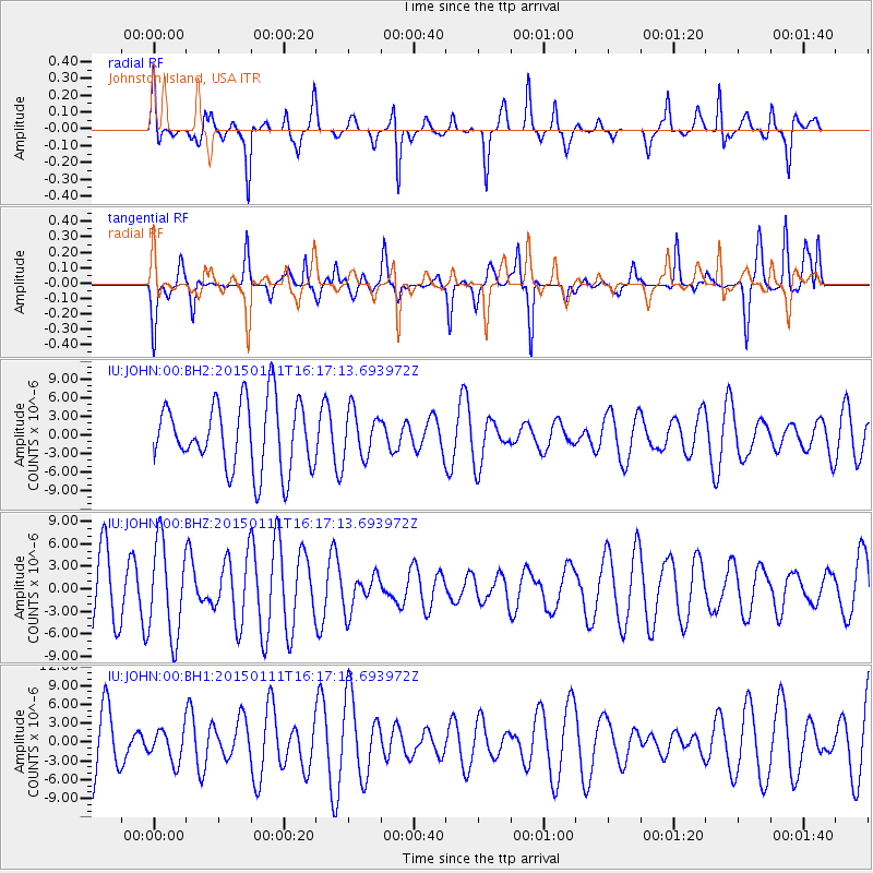
JOHN Johnston Island, USA - Earthquake Result Viewer
*The percent match for this event was below the threshold and hence no stack was calculated.
| Earthquake location: |
Philippine Islands Region |
| Earthquake latitude/longitude: |
11.6/126.1 |
| Earthquake time(UTC): |
2015/01/11 (011) 16:07:24 GMT |
| Earthquake Depth: |
28 km |
| Earthquake Magnitude: |
4.8 mb, 4.7 mb, 4.0 MS |
| Earthquake Catalog/Contributor: |
ISC/ISC |
|
| Network: |
IU Global Seismograph Network (GSN - IRIS/USGS) |
| Station: |
JOHN Johnston Island, USA |
| Lat/Lon: |
16.73 N/169.53 W |
| Elevation: |
2.0 m |
|
| Distance: |
62.4 deg |
| Az: |
77.096 deg |
| Baz: |
274.493 deg |
| Ray Param: |
$rayparam |
*The percent match for this event was below the threshold and hence was not used in the summary stack. |
|
| Radial Match: |
68.39248 % |
| Radial Bump: |
312 |
| Transverse Match: |
66.17338 % |
| Transverse Bump: |
320 |
| SOD ConfigId: |
3390531 |
| Insert Time: |
2019-04-16 00:39:10.866 +0000 |
| GWidth: |
2.5 |
| Max Bumps: |
400 |
| Tol: |
0.001 |
|
Signal To Noise
| Channel | StoN | STA | LTA |
| IU:JOHN:00:BHZ:20150111T16:17:13.693972Z | 1.549308 | 6.212733E-6 | 4.0100053E-6 |
| IU:JOHN:00:BH1:20150111T16:17:13.693972Z | 0.6680081 | 2.5716254E-6 | 3.849692E-6 |
| IU:JOHN:00:BH2:20150111T16:17:13.693972Z | 0.69273853 | 3.7850969E-6 | 5.463962E-6 |
| Arrivals |
| Ps | |
| PpPs | |
| PsPs/PpSs | |


