You are here: Home > Network List > TA - USArray Transportable Network (new EarthScope stations) Stations List
> Station N23A Red Feather Lakes, CO, USA > Earthquake Result Viewer
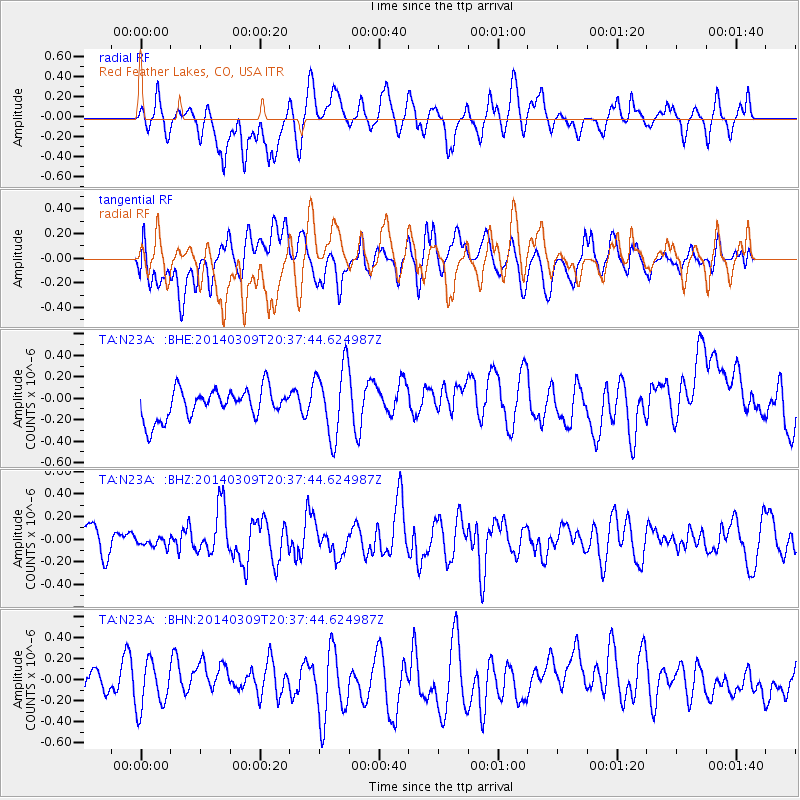
N23A Red Feather Lakes, CO, USA - Earthquake Result Viewer
*The percent match for this event was below the threshold and hence no stack was calculated.
| Earthquake location: |
Near Coast Of Ecuador |
| Earthquake latitude/longitude: |
1.7/-79.4 |
| Earthquake time(UTC): |
2014/03/09 (068) 20:29:52 GMT |
| Earthquake Depth: |
6.0 km |
| Earthquake Magnitude: |
5.6 MWW, 5.6 MWC, 5.6 MWB |
| Earthquake Catalog/Contributor: |
NEIC PDE/NEIC COMCAT |
|
| Network: |
TA USArray Transportable Network (new EarthScope stations) |
| Station: |
N23A Red Feather Lakes, CO, USA |
| Lat/Lon: |
40.89 N/105.94 W |
| Elevation: |
2458 m |
|
| Distance: |
45.9 deg |
| Az: |
331.777 deg |
| Baz: |
141.424 deg |
| Ray Param: |
$rayparam |
*The percent match for this event was below the threshold and hence was not used in the summary stack. |
|
| Radial Match: |
48.137943 % |
| Radial Bump: |
400 |
| Transverse Match: |
44.816174 % |
| Transverse Bump: |
400 |
| SOD ConfigId: |
626651 |
| Insert Time: |
2014-04-21 02:26:13.971 +0000 |
| GWidth: |
2.5 |
| Max Bumps: |
400 |
| Tol: |
0.001 |
|
Signal To Noise
| Channel | StoN | STA | LTA |
| TA:N23A: :BHZ:20140309T20:37:44.624987Z | 0.35434288 | 4.1489862E-8 | 1.170896E-7 |
| TA:N23A: :BHN:20140309T20:37:44.624987Z | 1.1081399 | 2.1478353E-7 | 1.9382347E-7 |
| TA:N23A: :BHE:20140309T20:37:44.624987Z | 2.3673675 | 3.306509E-7 | 1.3967029E-7 |
| Arrivals |
| Ps | |
| PpPs | |
| PsPs/PpSs | |


