You are here: Home > Network List > CI - Caltech Regional Seismic Network Stations List
> Station CIA CIA, Avalon Catalina Island, CA, USA > Earthquake Result Viewer
CIA CIA, Avalon Catalina Island, CA, USA - Earthquake Result Viewer
| Earthquake location: |
East Of Kuril Islands |
| Earthquake latitude/longitude: |
46.9/155.2 |
| Earthquake time(UTC): |
2009/01/15 (015) 17:49:39 GMT |
| Earthquake Depth: |
36 km |
| Earthquake Magnitude: |
6.9 MB, 7.5 MS, 7.4 MW, 7.4 MW |
| Earthquake Catalog/Contributor: |
WHDF/NEIC |
|
| Network: |
CI Caltech Regional Seismic Network |
| Station: |
CIA CIA, Avalon Catalina Island, CA, USA |
| Lat/Lon: |
33.40 N/118.41 W |
| Elevation: |
467 m |
|
| Distance: |
64.3 deg |
| Az: |
67.95 deg |
| Baz: |
310.503 deg |
| Ray Param: |
0.05897448 |
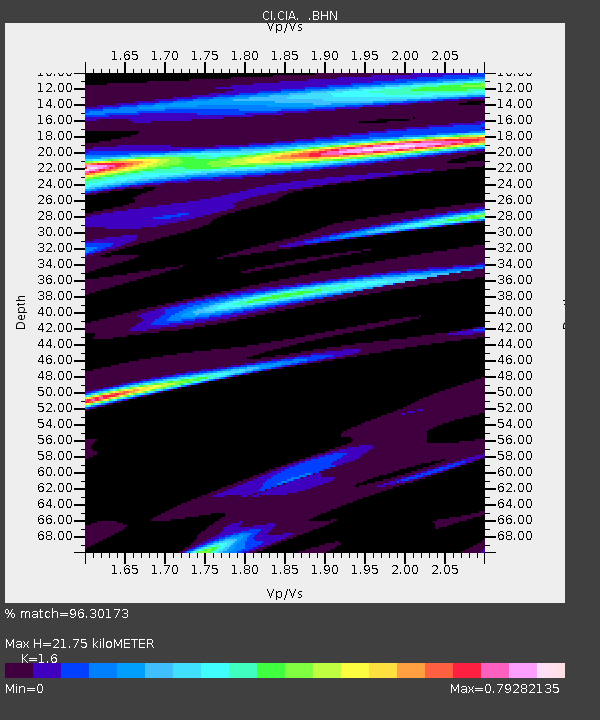
| Estimated Moho Depth: |
21.75 km |
| Estimated Crust Vp/Vs: |
1.60 |
| Assumed Crust Vp: |
6.048 km/s |
| Estimated Crust Vs: |
3.78 km/s |
| Estimated Crust Poisson's Ratio: |
0.18 |
|
| Radial Match: |
96.30173 % |
| Radial Bump: |
261 |
| Transverse Match: |
85.65874 % |
| Transverse Bump: |
374 |
| SOD ConfigId: |
2834 |
| Insert Time: |
2010-02-25 20:57:54.130 +0000 |
| GWidth: |
2.5 |
| Max Bumps: |
400 |
| Tol: |
0.001 |
|
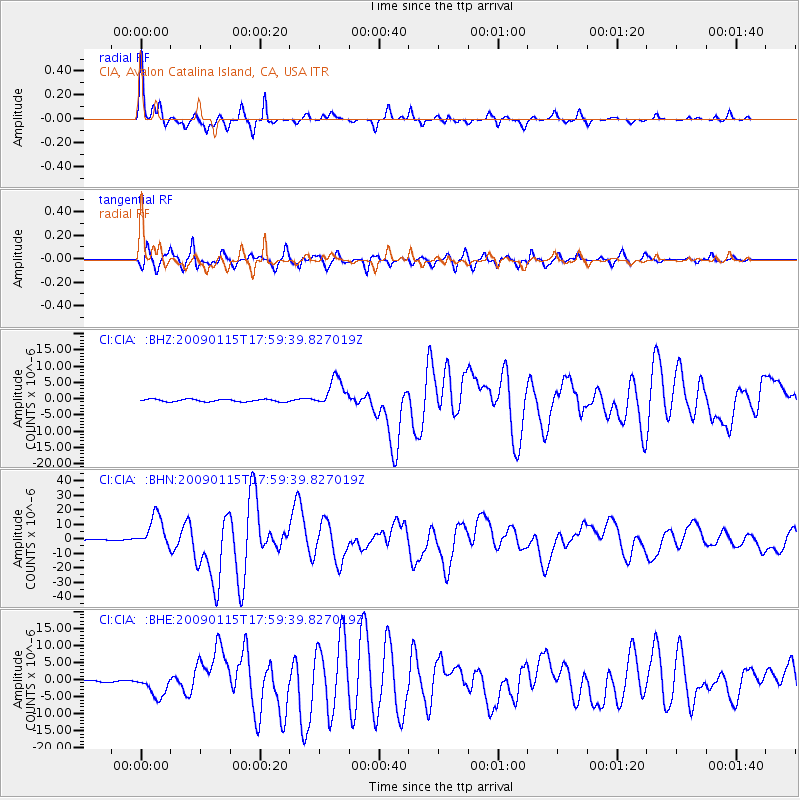
Signal To Noise
| Channel | StoN | STA | LTA |
| CI:CIA: :BHN:20090115T17:59:39.827019Z | 31.093925 | 1.1051538E-5 | 3.5542433E-7 |
| CI:CIA: :BHE:20090115T17:59:39.827019Z | 16.397444 | 3.3073547E-6 | 2.0169942E-7 |
| CI:CIA: :BHZ:20090115T17:59:39.827019Z | 11.58121 | 4.456242E-6 | 3.847821E-7 |
| Arrivals |
| Ps | 2.2 SECOND |
| PpPs | 9.0 SECOND |
| PsPs/PpSs | 11 SECOND |


