You are here: Home > Network List > US - United States National Seismic Network Stations List
> Station AMTX Amarillo, Texas, USA > Earthquake Result Viewer
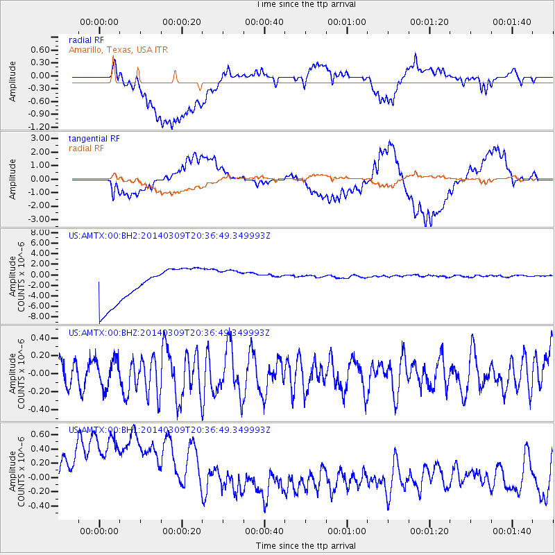
AMTX Amarillo, Texas, USA - Earthquake Result Viewer
*The percent match for this event was below the threshold and hence no stack was calculated.
| Earthquake location: |
Near Coast Of Ecuador |
| Earthquake latitude/longitude: |
1.7/-79.4 |
| Earthquake time(UTC): |
2014/03/09 (068) 20:29:52 GMT |
| Earthquake Depth: |
6.0 km |
| Earthquake Magnitude: |
5.6 MWW, 5.6 MWC, 5.6 MWB |
| Earthquake Catalog/Contributor: |
NEIC PDE/NEIC COMCAT |
|
| Network: |
US United States National Seismic Network |
| Station: |
AMTX Amarillo, Texas, USA |
| Lat/Lon: |
34.53 N/101.41 W |
| Elevation: |
1010 m |
|
| Distance: |
38.6 deg |
| Az: |
330.225 deg |
| Baz: |
143.04 deg |
| Ray Param: |
$rayparam |
*The percent match for this event was below the threshold and hence was not used in the summary stack. |
|
| Radial Match: |
49.99462 % |
| Radial Bump: |
400 |
| Transverse Match: |
30.524939 % |
| Transverse Bump: |
400 |
| SOD ConfigId: |
626651 |
| Insert Time: |
2014-04-21 02:29:13.049 +0000 |
| GWidth: |
2.5 |
| Max Bumps: |
400 |
| Tol: |
0.001 |
|
Signal To Noise
| Channel | StoN | STA | LTA |
| US:AMTX:00:BHZ:20140309T20:36:49.349993Z | 1.033104 | 1.582202E-7 | 1.5315034E-7 |
| US:AMTX:00:BH1:20140309T20:36:49.349993Z | 1.2983521 | 2.027206E-6 | 1.5613684E-6 |
| US:AMTX:00:BH2:20140309T20:36:49.349993Z | 1.0307504 | 3.275787E-6 | 3.1780605E-6 |
| Arrivals |
| Ps | |
| PpPs | |
| PsPs/PpSs | |


