You are here: Home > Network List > CI - Caltech Regional Seismic Network Stations List
> Station LRL Laurel Mtn Radio Fac, Ridgecrest, CA, USA > Earthquake Result Viewer
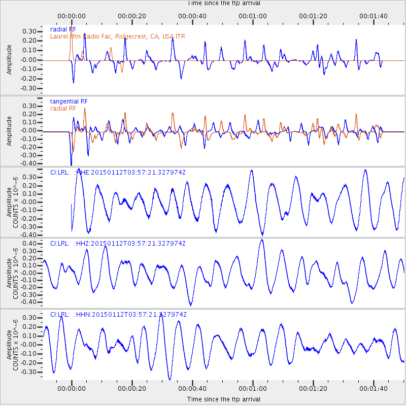
LRL Laurel Mtn Radio Fac, Ridgecrest, CA, USA - Earthquake Result Viewer
*The percent match for this event was below the threshold and hence no stack was calculated.
| Earthquake location: |
Eastern New Guinea Reg., P.N.G. |
| Earthquake latitude/longitude: |
-6.4/147.3 |
| Earthquake time(UTC): |
2015/01/12 (012) 03:44:23 GMT |
| Earthquake Depth: |
50 km |
| Earthquake Magnitude: |
4.6 mb, 4.7 mb, 4.0 MS |
| Earthquake Catalog/Contributor: |
ISC/ISC |
|
| Network: |
CI Caltech Regional Seismic Network |
| Station: |
LRL Laurel Mtn Radio Fac, Ridgecrest, CA, USA |
| Lat/Lon: |
35.48 N/117.68 W |
| Elevation: |
1340 m |
|
| Distance: |
97.8 deg |
| Az: |
55.138 deg |
| Baz: |
267.709 deg |
| Ray Param: |
$rayparam |
*The percent match for this event was below the threshold and hence was not used in the summary stack. |
|
| Radial Match: |
60.408047 % |
| Radial Bump: |
280 |
| Transverse Match: |
46.33289 % |
| Transverse Bump: |
368 |
| SOD ConfigId: |
3390531 |
| Insert Time: |
2019-04-16 00:43:24.292 +0000 |
| GWidth: |
2.5 |
| Max Bumps: |
400 |
| Tol: |
0.001 |
|
Signal To Noise
| Channel | StoN | STA | LTA |
| CI:LRL: :HHZ:20150112T03:57:21.327974Z | 0.895175 | 1.771501E-7 | 1.9789438E-7 |
| CI:LRL: :HHN:20150112T03:57:21.327974Z | 0.95089126 | 1.4601648E-7 | 1.535575E-7 |
| CI:LRL: :HHE:20150112T03:57:21.327974Z | 0.549064 | 9.328765E-8 | 1.6990307E-7 |
| Arrivals |
| Ps | |
| PpPs | |
| PsPs/PpSs | |


