You are here: Home > Network List > AV - Alaska Volcano Observatory Stations List
> Station SPCR Ckakachatna River, Mount Spurr, Alaska > Earthquake Result Viewer
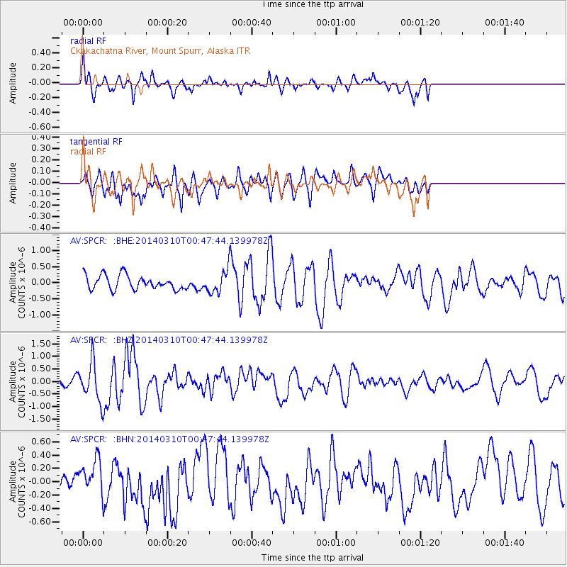
SPCR Ckakachatna River, Mount Spurr, Alaska - Earthquake Result Viewer
*The percent match for this event was below the threshold and hence no stack was calculated.
| Earthquake location: |
Near Coast Of Guerrero, Mexico |
| Earthquake latitude/longitude: |
16.0/-98.3 |
| Earthquake time(UTC): |
2014/03/10 (069) 00:38:15 GMT |
| Earthquake Depth: |
8.4 km |
| Earthquake Magnitude: |
5.8 MWW, 5.9 MWC, 6.0 MWB |
| Earthquake Catalog/Contributor: |
NEIC PDE/NEIC COMCAT |
|
| Network: |
AV Alaska Volcano Observatory |
| Station: |
SPCR Ckakachatna River, Mount Spurr, Alaska |
| Lat/Lon: |
61.20 N/152.21 W |
| Elevation: |
984 m |
|
| Distance: |
59.0 deg |
| Az: |
332.856 deg |
| Baz: |
115.052 deg |
| Ray Param: |
$rayparam |
*The percent match for this event was below the threshold and hence was not used in the summary stack. |
|
| Radial Match: |
70.49263 % |
| Radial Bump: |
400 |
| Transverse Match: |
62.89866 % |
| Transverse Bump: |
400 |
| SOD ConfigId: |
626651 |
| Insert Time: |
2014-04-21 02:36:16.234 +0000 |
| GWidth: |
2.5 |
| Max Bumps: |
400 |
| Tol: |
0.001 |
|
Signal To Noise
| Channel | StoN | STA | LTA |
| AV:SPCR: :BHZ:20140310T00:47:44.139978Z | 3.7449477 | 7.857427E-7 | 2.0981408E-7 |
| AV:SPCR: :BHN:20140310T00:47:44.139978Z | 1.1213052 | 2.7744963E-7 | 2.474345E-7 |
| AV:SPCR: :BHE:20140310T00:47:44.139978Z | 1.6593716 | 3.6738652E-7 | 2.2140098E-7 |
| Arrivals |
| Ps | |
| PpPs | |
| PsPs/PpSs | |


