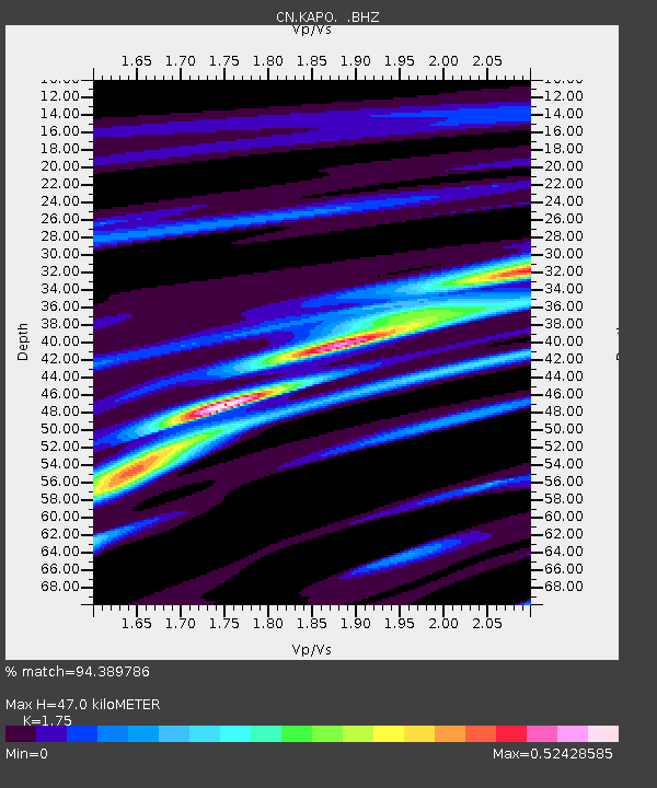
KAPO KAPUSKASING, ON - Earthquake Result Viewer

Earthquake location: Near Coast Of Guerrero, Mexico
Earthquake latitude/longitude: 16.0/-98.3
Earthquake time(UTC): 2014/03/10 (069) 00:38:15 GMT
Earthquake Depth: 8.4 km
Earthquake Magnitude: 5.8 MWW, 5.9 MWC, 6.0 MWB
Earthquake Catalog/Contributor: NEIC PDE/NEIC COMCAT
Network: CN Canadian National Seismograph Network
Station: KAPO KAPUSKASING, ON
Lat/Lon: 49.45 N/82.51 W
Elevation: 210 m
Distance: 35.7 deg
Az: 17.749 deg
Baz: 206.689 deg
Ray Param: 0.07707198
Estimated Moho Depth: 47.0 km
Estimated Crust Vp/Vs: 1.75
Assumed Crust Vp: 6.467 km/s
Estimated Crust Vs: 3.695 km/s
Estimated Crust Poisson's Ratio: 0.26
Radial Match: 94.389786 %
Radial Bump: 192
Transverse Match: 55.88393 %
Transverse Bump: 400
SOD ConfigId: 626651
Insert Time: 2014-04-21 02:37:54.559 +0000
GWidth: 2.5
Max Bumps: 400
Tol: 0.001

Signal To Noise

ChannelStoNSTALTA
CN:KAPO: :BHZ:20140310T00:44:43.274988Z7.35253761.323777E-61.8004356E-7
CN:KAPO: :BHN:20140310T00:44:43.274988Z4.2078147.1925353E-71.7093282E-7
CN:KAPO: :BHE:20140310T00:44:43.274988Z4.99600365.605481E-71.1219929E-7
Arrivals
Ps5.9 SECOND
PpPs18 SECOND
PsPs/PpSs24 SECOND