You are here: Home > Network List > G - GEOSCOPE Stations List
> Station MPG Montagne des Peres, French Guyana > Earthquake Result Viewer
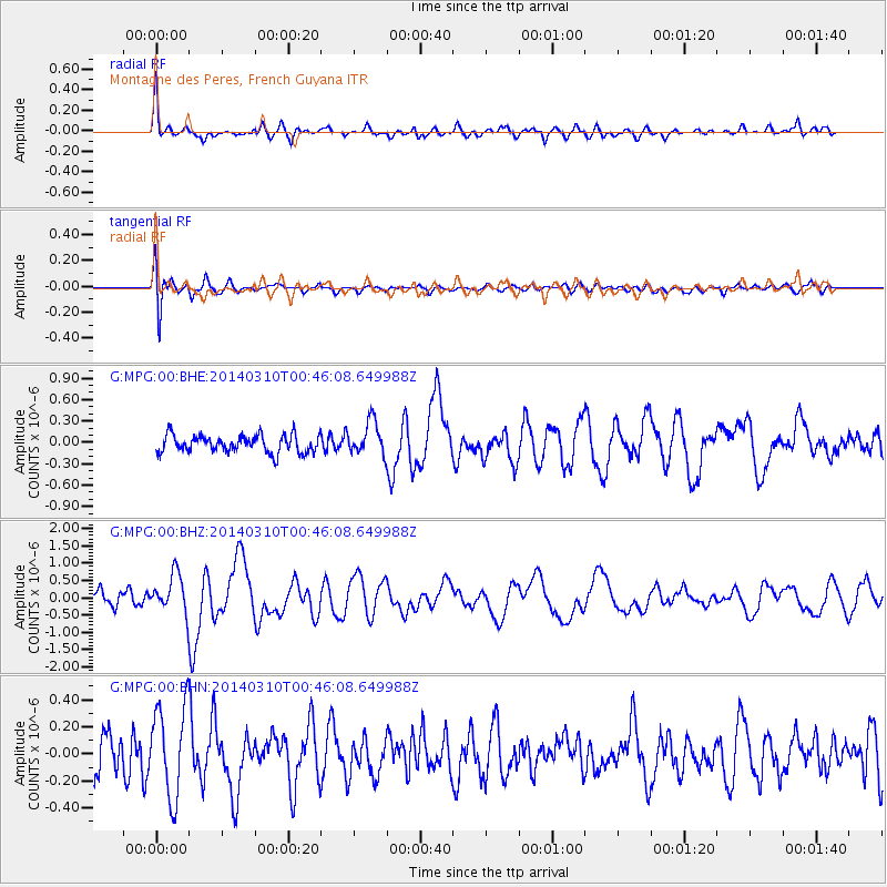
MPG Montagne des Peres, French Guyana - Earthquake Result Viewer
*The percent match for this event was below the threshold and hence no stack was calculated.
| Earthquake location: |
Near Coast Of Guerrero, Mexico |
| Earthquake latitude/longitude: |
16.0/-98.3 |
| Earthquake time(UTC): |
2014/03/10 (069) 00:38:15 GMT |
| Earthquake Depth: |
8.4 km |
| Earthquake Magnitude: |
5.8 MWW, 5.9 MWC, 6.0 MWB |
| Earthquake Catalog/Contributor: |
NEIC PDE/NEIC COMCAT |
|
| Network: |
G GEOSCOPE |
| Station: |
MPG Montagne des Peres, French Guyana |
| Lat/Lon: |
5.11 N/52.64 W |
| Elevation: |
147 m |
|
| Distance: |
46.1 deg |
| Az: |
98.459 deg |
| Baz: |
287.285 deg |
| Ray Param: |
$rayparam |
*The percent match for this event was below the threshold and hence was not used in the summary stack. |
|
| Radial Match: |
77.045975 % |
| Radial Bump: |
400 |
| Transverse Match: |
61.068207 % |
| Transverse Bump: |
400 |
| SOD ConfigId: |
626651 |
| Insert Time: |
2014-04-21 02:39:35.705 +0000 |
| GWidth: |
2.5 |
| Max Bumps: |
400 |
| Tol: |
0.001 |
|
Signal To Noise
| Channel | StoN | STA | LTA |
| G:MPG:00:BHZ:20140310T00:46:08.649988Z | 2.653313 | 5.501356E-7 | 2.0733913E-7 |
| G:MPG:00:BHN:20140310T00:46:08.649988Z | 1.6789091 | 3.3658472E-7 | 2.0047824E-7 |
| G:MPG:00:BHE:20140310T00:46:08.649988Z | 1.9534128 | 2.3605256E-7 | 1.2084111E-7 |
| Arrivals |
| Ps | |
| PpPs | |
| PsPs/PpSs | |


