You are here: Home > Network List > CI - Caltech Regional Seismic Network Stations List
> Station CIA CIA, Avalon Catalina Island, CA, USA > Earthquake Result Viewer
CIA CIA, Avalon Catalina Island, CA, USA - Earthquake Result Viewer
| Earthquake location: |
Fiji Islands Region |
| Earthquake latitude/longitude: |
-21.6/-176.4 |
| Earthquake time(UTC): |
1998/12/27 (361) 00:38:26 GMT |
| Earthquake Depth: |
144 km |
| Earthquake Magnitude: |
6.1 MB, 6.9 UNKNOWN, 6.6 ME |
| Earthquake Catalog/Contributor: |
WHDF/NEIC |
|
| Network: |
CI Caltech Regional Seismic Network |
| Station: |
CIA CIA, Avalon Catalina Island, CA, USA |
| Lat/Lon: |
33.40 N/118.41 W |
| Elevation: |
467 m |
|
| Distance: |
77.8 deg |
| Az: |
46.521 deg |
| Baz: |
233.81 deg |
| Ray Param: |
0.049753785 |
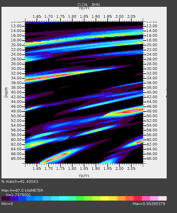
| Estimated Moho Depth: |
67.0 km |
| Estimated Crust Vp/Vs: |
1.74 |
| Assumed Crust Vp: |
6.048 km/s |
| Estimated Crust Vs: |
3.481 km/s |
| Estimated Crust Poisson's Ratio: |
0.25 |
|
| Radial Match: |
91.40043 % |
| Radial Bump: |
400 |
| Transverse Match: |
85.3306 % |
| Transverse Bump: |
400 |
| SOD ConfigId: |
3787 |
| Insert Time: |
2010-02-25 20:57:56.227 +0000 |
| GWidth: |
2.5 |
| Max Bumps: |
400 |
| Tol: |
0.001 |
|
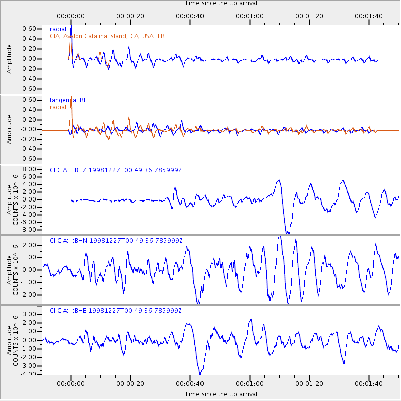
Signal To Noise
| Channel | StoN | STA | LTA |
| CI:CIA: :BHN:19981227T00:49:36.785999Z | 1.5768462 | 4.2590955E-7 | 2.7010216E-7 |
| CI:CIA: :BHE:19981227T00:49:36.785999Z | 2.4709125 | 3.487773E-7 | 1.4115325E-7 |
| CI:CIA: :BHZ:19981227T00:49:36.785999Z | 4.949398 | 9.751424E-7 | 1.9702242E-7 |
| Arrivals |
| Ps | 8.4 SECOND |
| PpPs | 30 SECOND |
| PsPs/PpSs | 38 SECOND |


