You are here: Home > Network List > TA - USArray Transportable Network (new EarthScope stations) Stations List
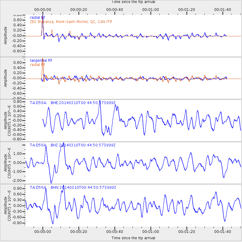
> Station D56A ZEC Mazanza, Mont-Saint-Michel, QC, CAN > Earthquake Result Viewer
D56A ZEC Mazanza, Mont-Saint-Michel, QC, CAN - Earthquake Result Viewer
| Earthquake location: |
Near Coast Of Guerrero, Mexico |
| Earthquake latitude/longitude: |
16.0/-98.3 |
| Earthquake time(UTC): |
2014/03/10 (069) 00:38:15 GMT |
| Earthquake Depth: |
8.4 km |
| Earthquake Magnitude: |
5.8 MWW, 5.9 MWC, 6.0 MWB |
| Earthquake Catalog/Contributor: |
NEIC PDE/NEIC COMCAT |
|
| Network: |
TA USArray Transportable Network (new EarthScope stations) |
| Station: |
D56A ZEC Mazanza, Mont-Saint-Michel, QC, CAN |
| Lat/Lon: |
47.05 N/74.76 W |
| Elevation: |
421 m |
|
| Distance: |
36.6 deg |
| Az: |
27.322 deg |
| Baz: |
220.196 deg |
| Ray Param: |
0.07660658 |
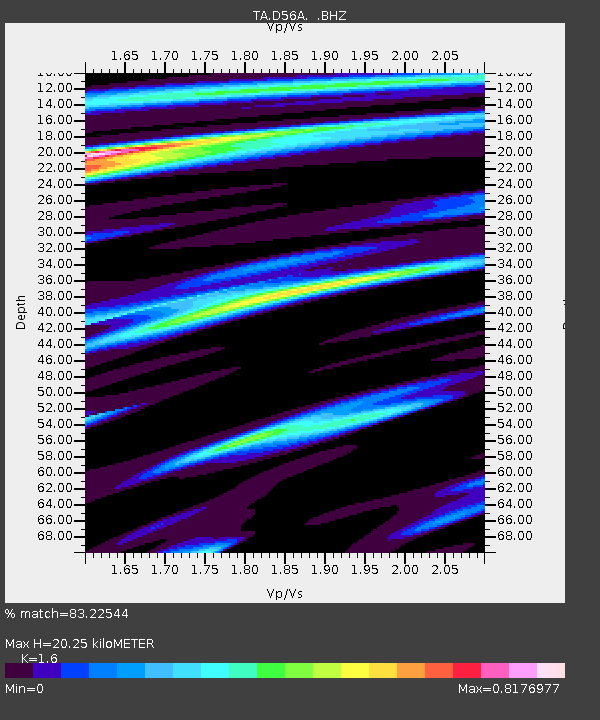
| Estimated Moho Depth: |
20.25 km |
| Estimated Crust Vp/Vs: |
1.60 |
| Assumed Crust Vp: |
6.61 km/s |
| Estimated Crust Vs: |
4.131 km/s |
| Estimated Crust Poisson's Ratio: |
0.18 |
|
| Radial Match: |
83.22544 % |
| Radial Bump: |
400 |
| Transverse Match: |
55.560375 % |
| Transverse Bump: |
400 |
| SOD ConfigId: |
626651 |
| Insert Time: |
2014-04-21 02:46:30.462 +0000 |
| GWidth: |
2.5 |
| Max Bumps: |
400 |
| Tol: |
0.001 |
|
Signal To Noise
| Channel | StoN | STA | LTA |
| TA:D56A: :BHZ:20140310T00:44:50.573999Z | 4.8380375 | 1.0637199E-6 | 2.1986598E-7 |
| TA:D56A: :BHN:20140310T00:44:50.573999Z | 2.7725298 | 4.1829244E-7 | 1.508703E-7 |
| TA:D56A: :BHE:20140310T00:44:50.573999Z | 1.8882776 | 4.6001477E-7 | 2.4361609E-7 |
| Arrivals |
| Ps | 2.0 SECOND |
| PpPs | 7.3 SECOND |
| PsPs/PpSs | 9.3 SECOND |


