You are here: Home > Network List > TA - USArray Transportable Network (new EarthScope stations) Stations List
> Station D57A Chemin Vers le Barrage, Saint-Michel-Des-Saints, Q > Earthquake Result Viewer
D57A Chemin Vers le Barrage, Saint-Michel-Des-Saints, Q - Earthquake Result Viewer

| Earthquake location: |
Near Coast Of Guerrero, Mexico |
| Earthquake latitude/longitude: |
16.0/-98.3 |
| Earthquake time(UTC): |
2014/03/10 (069) 00:38:15 GMT |
| Earthquake Depth: |
8.4 km |
| Earthquake Magnitude: |
5.8 MWW, 5.9 MWC, 6.0 MWB |
| Earthquake Catalog/Contributor: |
NEIC PDE/NEIC COMCAT |
|
| Network: |
TA USArray Transportable Network (new EarthScope stations) |
| Station: |
D57A Chemin Vers le Barrage, Saint-Michel-Des-Saints, Q |
| Lat/Lon: |
47.02 N/73.89 W |
| Elevation: |
422 m |
|
| Distance: |
36.9 deg |
| Az: |
28.108 deg |
| Baz: |
221.459 deg |
| Ray Param: |
0.07640777 |
| Estimated Moho Depth: |
59.25 km |
| Estimated Crust Vp/Vs: |
1.98 |
| Assumed Crust Vp: |
6.61 km/s |
| Estimated Crust Vs: |
3.343 km/s |
| Estimated Crust Poisson's Ratio: |
0.33 |
|
| Radial Match: |
82.22596 % |
| Radial Bump: |
400 |
| Transverse Match: |
56.935513 % |
| Transverse Bump: |
400 |
| SOD ConfigId: |
626651 |
| Insert Time: |
2014-04-21 02:46:35.232 +0000 |
| GWidth: |
2.5 |
| Max Bumps: |
400 |
| Tol: |
0.001 |
|
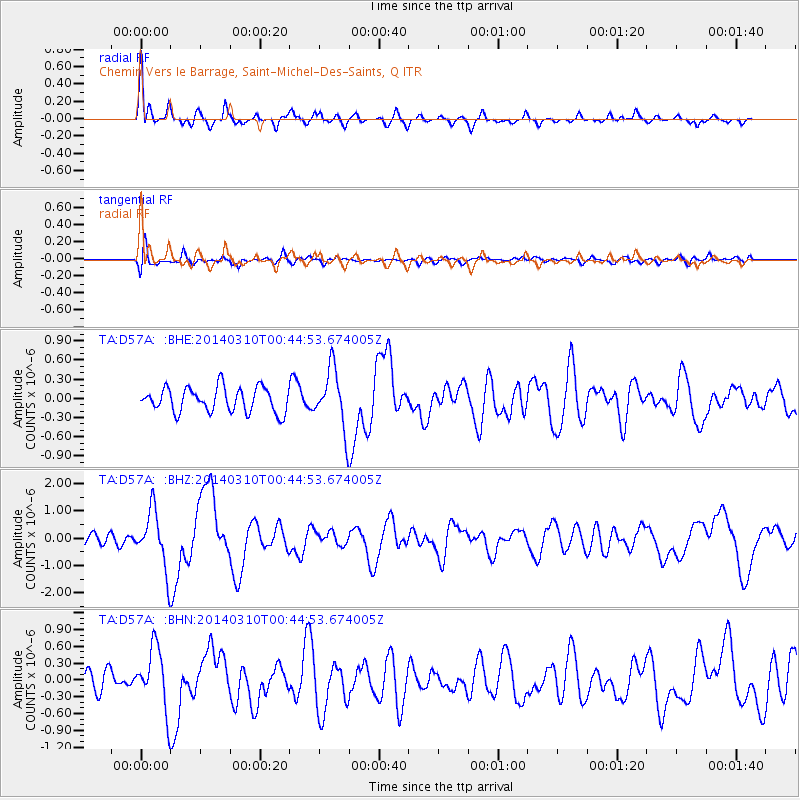
Signal To Noise
| Channel | StoN | STA | LTA |
| TA:D57A: :BHZ:20140310T00:44:53.674005Z | 3.98859 | 1.0566978E-6 | 2.6493015E-7 |
| TA:D57A: :BHN:20140310T00:44:53.674005Z | 2.3162787 | 5.461207E-7 | 2.3577505E-7 |
| TA:D57A: :BHE:20140310T00:44:53.674005Z | 2.4085667 | 4.603635E-7 | 1.9113588E-7 |
| Arrivals |
| Ps | 9.4 SECOND |
| PpPs | 25 SECOND |
| PsPs/PpSs | 34 SECOND |


