You are here: Home > Network List > TA - USArray Transportable Network (new EarthScope stations) Stations List
> Station E59A St. Maurice, QC, CAN > Earthquake Result Viewer
E59A St. Maurice, QC, CAN - Earthquake Result Viewer
| Earthquake location: |
Near Coast Of Guerrero, Mexico |
| Earthquake latitude/longitude: |
16.0/-98.3 |
| Earthquake time(UTC): |
2014/03/10 (069) 00:38:15 GMT |
| Earthquake Depth: |
8.4 km |
| Earthquake Magnitude: |
5.8 MWW, 5.9 MWC, 6.0 MWB |
| Earthquake Catalog/Contributor: |
NEIC PDE/NEIC COMCAT |
|
| Network: |
TA USArray Transportable Network (new EarthScope stations) |
| Station: |
E59A St. Maurice, QC, CAN |
| Lat/Lon: |
46.48 N/72.51 W |
| Elevation: |
62 m |
|
| Distance: |
37.2 deg |
| Az: |
29.867 deg |
| Baz: |
223.862 deg |
| Ray Param: |
0.07627336 |
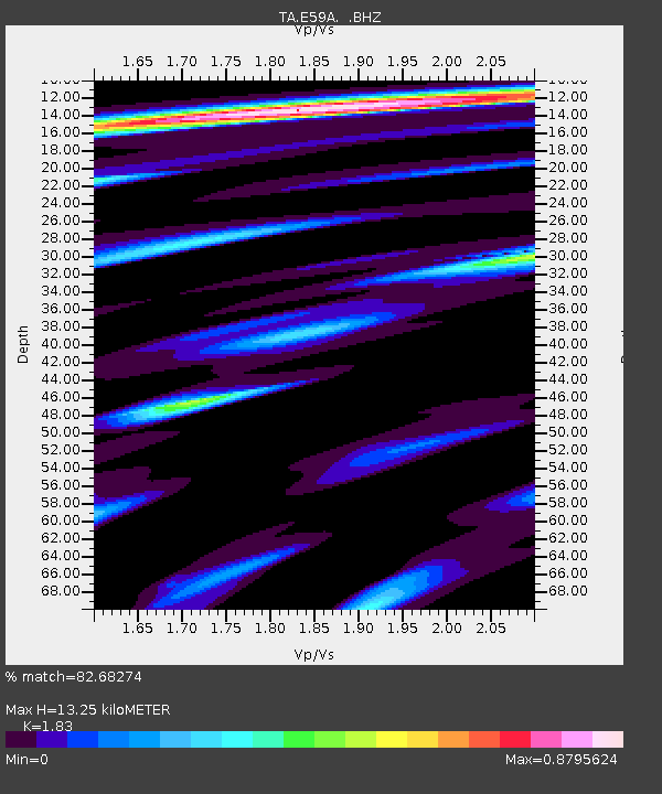
| Estimated Moho Depth: |
13.25 km |
| Estimated Crust Vp/Vs: |
1.83 |
| Assumed Crust Vp: |
6.61 km/s |
| Estimated Crust Vs: |
3.612 km/s |
| Estimated Crust Poisson's Ratio: |
0.29 |
|
| Radial Match: |
82.68274 % |
| Radial Bump: |
400 |
| Transverse Match: |
66.66792 % |
| Transverse Bump: |
400 |
| SOD ConfigId: |
626651 |
| Insert Time: |
2014-04-21 02:47:18.467 +0000 |
| GWidth: |
2.5 |
| Max Bumps: |
400 |
| Tol: |
0.001 |
|
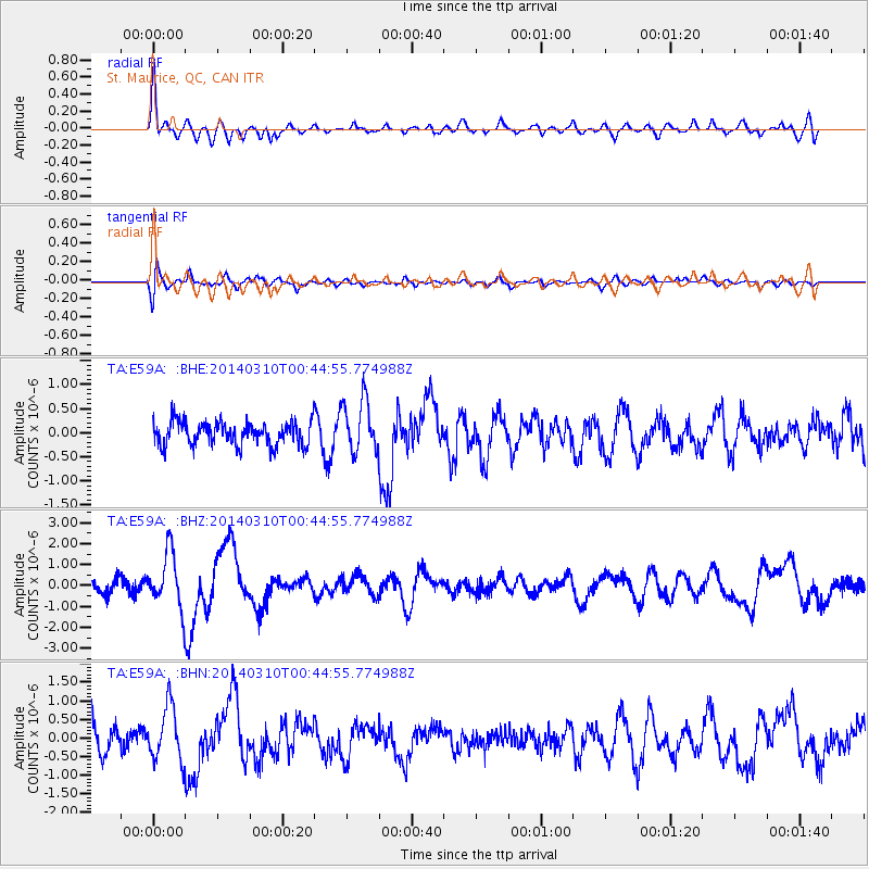
Signal To Noise
| Channel | StoN | STA | LTA |
| TA:E59A: :BHZ:20140310T00:44:55.774988Z | 3.5055254 | 1.3254233E-6 | 3.7809548E-7 |
| TA:E59A: :BHN:20140310T00:44:55.774988Z | 2.4432669 | 7.326017E-7 | 2.9984514E-7 |
| TA:E59A: :BHE:20140310T00:44:55.774988Z | 2.2847242 | 5.5012333E-7 | 2.4078327E-7 |
| Arrivals |
| Ps | 1.8 SECOND |
| PpPs | 5.3 SECOND |
| PsPs/PpSs | 7.1 SECOND |


