You are here: Home > Network List > TA - USArray Transportable Network (new EarthScope stations) Stations List
> Station F55A Otter Lake, QC, CAN > Earthquake Result Viewer
F55A Otter Lake, QC, CAN - Earthquake Result Viewer
| Earthquake location: |
Near Coast Of Guerrero, Mexico |
| Earthquake latitude/longitude: |
16.0/-98.3 |
| Earthquake time(UTC): |
2014/03/10 (069) 00:38:15 GMT |
| Earthquake Depth: |
8.4 km |
| Earthquake Magnitude: |
5.8 MWW, 5.9 MWC, 6.0 MWB |
| Earthquake Catalog/Contributor: |
NEIC PDE/NEIC COMCAT |
|
| Network: |
TA USArray Transportable Network (new EarthScope stations) |
| Station: |
F55A Otter Lake, QC, CAN |
| Lat/Lon: |
45.83 N/76.35 W |
| Elevation: |
218 m |
|
| Distance: |
34.9 deg |
| Az: |
27.192 deg |
| Baz: |
218.939 deg |
| Ray Param: |
0.07748471 |
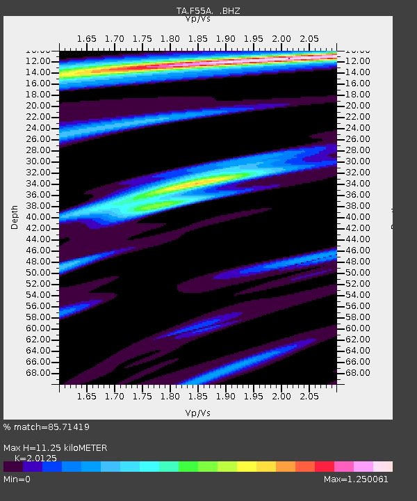
| Estimated Moho Depth: |
11.25 km |
| Estimated Crust Vp/Vs: |
2.01 |
| Assumed Crust Vp: |
6.577 km/s |
| Estimated Crust Vs: |
3.268 km/s |
| Estimated Crust Poisson's Ratio: |
0.34 |
|
| Radial Match: |
85.71419 % |
| Radial Bump: |
400 |
| Transverse Match: |
59.698997 % |
| Transverse Bump: |
400 |
| SOD ConfigId: |
626651 |
| Insert Time: |
2014-04-21 02:47:48.311 +0000 |
| GWidth: |
2.5 |
| Max Bumps: |
400 |
| Tol: |
0.001 |
|
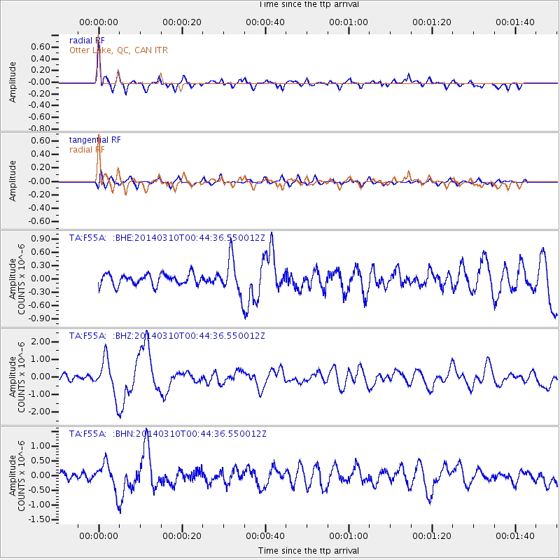
Signal To Noise
| Channel | StoN | STA | LTA |
| TA:F55A: :BHZ:20140310T00:44:36.550012Z | 6.288572 | 1.0830123E-6 | 1.7221912E-7 |
| TA:F55A: :BHN:20140310T00:44:36.550012Z | 3.467415 | 4.885245E-7 | 1.4089012E-7 |
| TA:F55A: :BHE:20140310T00:44:36.550012Z | 3.4226372 | 4.2399796E-7 | 1.2388048E-7 |
| Arrivals |
| Ps | 1.9 SECOND |
| PpPs | 4.8 SECOND |
| PsPs/PpSs | 6.7 SECOND |


