You are here: Home > Network List > TA - USArray Transportable Network (new EarthScope stations) Stations List
> Station H53A Bobcaygeon, ON, CAN > Earthquake Result Viewer
H53A Bobcaygeon, ON, CAN - Earthquake Result Viewer
| Earthquake location: |
Near Coast Of Guerrero, Mexico |
| Earthquake latitude/longitude: |
16.0/-98.3 |
| Earthquake time(UTC): |
2014/03/10 (069) 00:38:15 GMT |
| Earthquake Depth: |
8.4 km |
| Earthquake Magnitude: |
5.8 MWW, 5.9 MWC, 6.0 MWB |
| Earthquake Catalog/Contributor: |
NEIC PDE/NEIC COMCAT |
|
| Network: |
TA USArray Transportable Network (new EarthScope stations) |
| Station: |
H53A Bobcaygeon, ON, CAN |
| Lat/Lon: |
44.57 N/78.58 W |
| Elevation: |
292 m |
|
| Distance: |
33.0 deg |
| Az: |
26.342 deg |
| Baz: |
216.655 deg |
| Ray Param: |
0.078422636 |
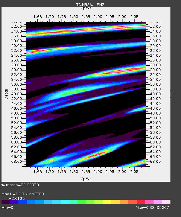
| Estimated Moho Depth: |
12.0 km |
| Estimated Crust Vp/Vs: |
2.01 |
| Assumed Crust Vp: |
6.577 km/s |
| Estimated Crust Vs: |
3.268 km/s |
| Estimated Crust Poisson's Ratio: |
0.34 |
|
| Radial Match: |
83.93978 % |
| Radial Bump: |
275 |
| Transverse Match: |
51.13534 % |
| Transverse Bump: |
400 |
| SOD ConfigId: |
626651 |
| Insert Time: |
2014-04-21 02:49:01.502 +0000 |
| GWidth: |
2.5 |
| Max Bumps: |
400 |
| Tol: |
0.001 |
|

Signal To Noise
| Channel | StoN | STA | LTA |
| TA:H53A: :BHZ:20140310T00:44:19.550012Z | 5.5529094 | 1.1500955E-6 | 2.0711585E-7 |
| TA:H53A: :BHN:20140310T00:44:19.550012Z | 3.4105442 | 5.337398E-7 | 1.5649697E-7 |
| TA:H53A: :BHE:20140310T00:44:19.550012Z | 5.107525 | 5.3607795E-7 | 1.0495847E-7 |
| Arrivals |
| Ps | 2.0 SECOND |
| PpPs | 5.1 SECOND |
| PsPs/PpSs | 7.1 SECOND |


