You are here: Home > Network List > TA - USArray Transportable Network (new EarthScope stations) Stations List
> Station H57A Richville, NY, USA > Earthquake Result Viewer
H57A Richville, NY, USA - Earthquake Result Viewer
| Earthquake location: |
Near Coast Of Guerrero, Mexico |
| Earthquake latitude/longitude: |
16.0/-98.3 |
| Earthquake time(UTC): |
2014/03/10 (069) 00:38:15 GMT |
| Earthquake Depth: |
8.4 km |
| Earthquake Magnitude: |
5.8 MWW, 5.9 MWC, 6.0 MWB |
| Earthquake Catalog/Contributor: |
NEIC PDE/NEIC COMCAT |
|
| Network: |
TA USArray Transportable Network (new EarthScope stations) |
| Station: |
H57A Richville, NY, USA |
| Lat/Lon: |
44.46 N/75.39 W |
| Elevation: |
132 m |
|
| Distance: |
34.3 deg |
| Az: |
29.665 deg |
| Baz: |
221.652 deg |
| Ray Param: |
0.07779754 |
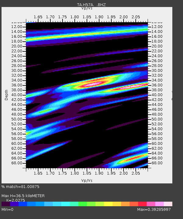
| Estimated Moho Depth: |
36.5 km |
| Estimated Crust Vp/Vs: |
2.03 |
| Assumed Crust Vp: |
6.419 km/s |
| Estimated Crust Vs: |
3.166 km/s |
| Estimated Crust Poisson's Ratio: |
0.34 |
|
| Radial Match: |
81.00875 % |
| Radial Bump: |
371 |
| Transverse Match: |
60.456356 % |
| Transverse Bump: |
400 |
| SOD ConfigId: |
626651 |
| Insert Time: |
2014-04-21 02:49:07.823 +0000 |
| GWidth: |
2.5 |
| Max Bumps: |
400 |
| Tol: |
0.001 |
|
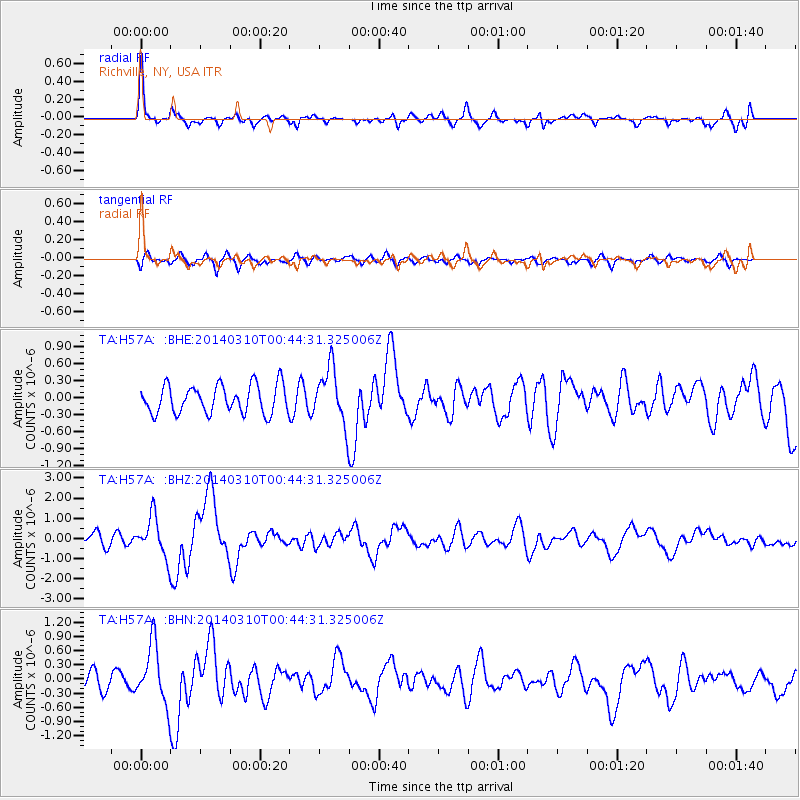
Signal To Noise
| Channel | StoN | STA | LTA |
| TA:H57A: :BHZ:20140310T00:44:31.325006Z | 3.2352316 | 9.883125E-7 | 3.0548432E-7 |
| TA:H57A: :BHN:20140310T00:44:31.325006Z | 3.9831278 | 6.2032086E-7 | 1.5573713E-7 |
| TA:H57A: :BHE:20140310T00:44:31.325006Z | 1.9653972 | 4.870798E-7 | 2.4782764E-7 |
| Arrivals |
| Ps | 6.2 SECOND |
| PpPs | 16 SECOND |
| PsPs/PpSs | 22 SECOND |


