You are here: Home > Network List > TA - USArray Transportable Network (new EarthScope stations) Stations List
> Station H61A Lyndonville, VT, USA > Earthquake Result Viewer
H61A Lyndonville, VT, USA - Earthquake Result Viewer
| Earthquake location: |
Near Coast Of Guerrero, Mexico |
| Earthquake latitude/longitude: |
16.0/-98.3 |
| Earthquake time(UTC): |
2014/03/10 (069) 00:38:15 GMT |
| Earthquake Depth: |
8.4 km |
| Earthquake Magnitude: |
5.8 MWW, 5.9 MWC, 6.0 MWB |
| Earthquake Catalog/Contributor: |
NEIC PDE/NEIC COMCAT |
|
| Network: |
TA USArray Transportable Network (new EarthScope stations) |
| Station: |
H61A Lyndonville, VT, USA |
| Lat/Lon: |
44.53 N/71.93 W |
| Elevation: |
462 m |
|
| Distance: |
36.1 deg |
| Az: |
32.665 deg |
| Baz: |
226.523 deg |
| Ray Param: |
0.076862186 |
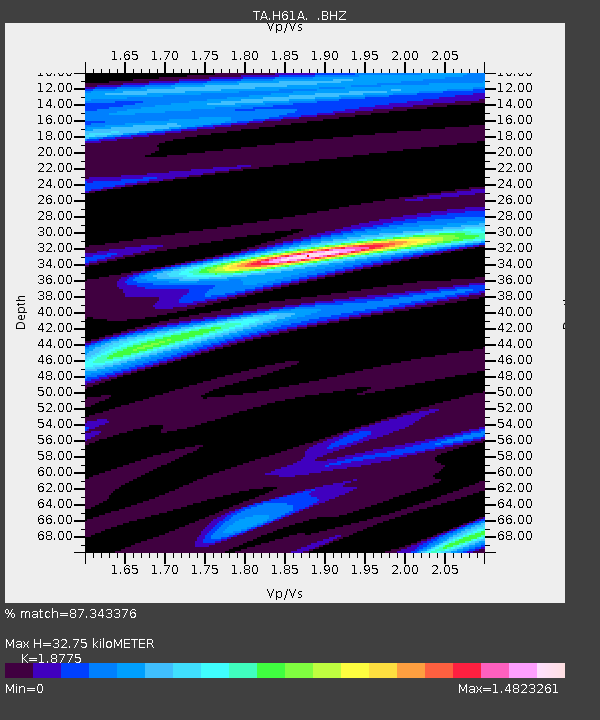
| Estimated Moho Depth: |
32.75 km |
| Estimated Crust Vp/Vs: |
1.88 |
| Assumed Crust Vp: |
6.419 km/s |
| Estimated Crust Vs: |
3.419 km/s |
| Estimated Crust Poisson's Ratio: |
0.30 |
|
| Radial Match: |
87.343376 % |
| Radial Bump: |
400 |
| Transverse Match: |
67.08889 % |
| Transverse Bump: |
400 |
| SOD ConfigId: |
626651 |
| Insert Time: |
2014-04-21 02:49:17.817 +0000 |
| GWidth: |
2.5 |
| Max Bumps: |
400 |
| Tol: |
0.001 |
|

Signal To Noise
| Channel | StoN | STA | LTA |
| TA:H61A: :BHZ:20140310T00:44:46.575006Z | 3.0710363 | 1.0209483E-6 | 3.3244424E-7 |
| TA:H61A: :BHN:20140310T00:44:46.575006Z | 2.5443401 | 6.9323175E-7 | 2.7246034E-7 |
| TA:H61A: :BHE:20140310T00:44:46.575006Z | 2.2460136 | 5.8832677E-7 | 2.6194263E-7 |
| Arrivals |
| Ps | 4.8 SECOND |
| PpPs | 14 SECOND |
| PsPs/PpSs | 18 SECOND |


