You are here: Home > Network List > TA - USArray Transportable Network (new EarthScope stations) Stations List
> Station H63A New Sharon, ME, USA > Earthquake Result Viewer
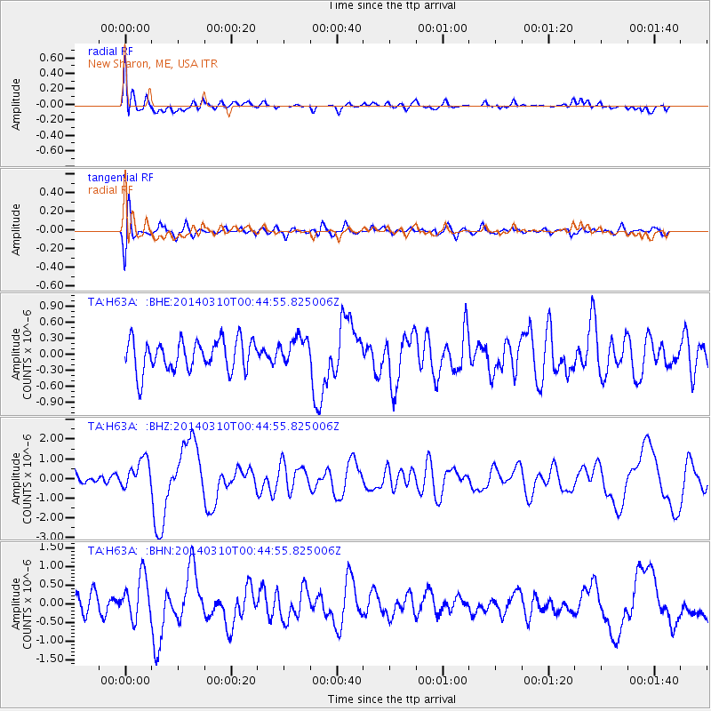
H63A New Sharon, ME, USA - Earthquake Result Viewer
*The percent match for this event was below the threshold and hence no stack was calculated.
| Earthquake location: |
Near Coast Of Guerrero, Mexico |
| Earthquake latitude/longitude: |
16.0/-98.3 |
| Earthquake time(UTC): |
2014/03/10 (069) 00:38:15 GMT |
| Earthquake Depth: |
8.4 km |
| Earthquake Magnitude: |
5.8 MWW, 5.9 MWC, 6.0 MWB |
| Earthquake Catalog/Contributor: |
NEIC PDE/NEIC COMCAT |
|
| Network: |
TA USArray Transportable Network (new EarthScope stations) |
| Station: |
H63A New Sharon, ME, USA |
| Lat/Lon: |
44.66 N/70.04 W |
| Elevation: |
109 m |
|
| Distance: |
37.2 deg |
| Az: |
34.029 deg |
| Baz: |
228.941 deg |
| Ray Param: |
$rayparam |
*The percent match for this event was below the threshold and hence was not used in the summary stack. |
|
| Radial Match: |
73.96033 % |
| Radial Bump: |
400 |
| Transverse Match: |
71.21349 % |
| Transverse Bump: |
400 |
| SOD ConfigId: |
626651 |
| Insert Time: |
2014-04-21 02:49:22.548 +0000 |
| GWidth: |
2.5 |
| Max Bumps: |
400 |
| Tol: |
0.001 |
|
Signal To Noise
| Channel | StoN | STA | LTA |
| TA:H63A: :BHZ:20140310T00:44:55.825006Z | 2.1457138 | 7.5203775E-7 | 3.5048373E-7 |
| TA:H63A: :BHN:20140310T00:44:55.825006Z | 2.1893852 | 5.812532E-7 | 2.6548693E-7 |
| TA:H63A: :BHE:20140310T00:44:55.825006Z | 0.90093935 | 2.6188806E-7 | 2.9068335E-7 |
| Arrivals |
| Ps | |
| PpPs | |
| PsPs/PpSs | |


